You are here: Home > Network List > TA - USArray Transportable Network (new EarthScope stations) Stations List
> Station 426A McDonald Observatory, Fort Davis, TX, USA > Earthquake Result Viewer
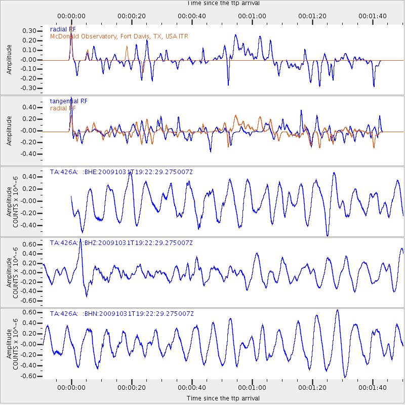
426A McDonald Observatory, Fort Davis, TX, USA - Earthquake Result Viewer
*The percent match for this event was below the threshold and hence no stack was calculated.
| Earthquake location: |
Santa Cruz Islands |
| Earthquake latitude/longitude: |
-11.4/166.4 |
| Earthquake time(UTC): |
2009/10/31 (304) 19:09:51 GMT |
| Earthquake Depth: |
134 km |
| Earthquake Magnitude: |
5.9 MB, 5.9 MW, 5.9 MW |
| Earthquake Catalog/Contributor: |
WHDF/NEIC |
|
| Network: |
TA USArray Transportable Network (new EarthScope stations) |
| Station: |
426A McDonald Observatory, Fort Davis, TX, USA |
| Lat/Lon: |
30.67 N/104.03 W |
| Elevation: |
1943 m |
|
| Distance: |
95.4 deg |
| Az: |
59.928 deg |
| Baz: |
260.03 deg |
| Ray Param: |
$rayparam |
*The percent match for this event was below the threshold and hence was not used in the summary stack. |
|
| Radial Match: |
47.497696 % |
| Radial Bump: |
400 |
| Transverse Match: |
53.062534 % |
| Transverse Bump: |
400 |
| SOD ConfigId: |
2622 |
| Insert Time: |
2010-03-06 16:59:45.891 +0000 |
| GWidth: |
2.5 |
| Max Bumps: |
400 |
| Tol: |
0.001 |
|
Signal To Noise
| Channel | StoN | STA | LTA |
| TA:426A: :BHZ:20091031T19:22:29.275007Z | 1.7686788 | 3.1292103E-7 | 1.7692359E-7 |
| TA:426A: :BHN:20091031T19:22:29.275007Z | 1.2884583 | 2.2629561E-7 | 1.7563285E-7 |
| TA:426A: :BHE:20091031T19:22:29.275007Z | 0.7211365 | 1.8092527E-7 | 2.5088906E-7 |
| Arrivals |
| Ps | |
| PpPs | |
| PsPs/PpSs | |


