You are here: Home > Network List > TA - USArray Transportable Network (new EarthScope stations) Stations List
> Station N25K Chitina, Valdez-Cordova, AK, USA > Earthquake Result Viewer
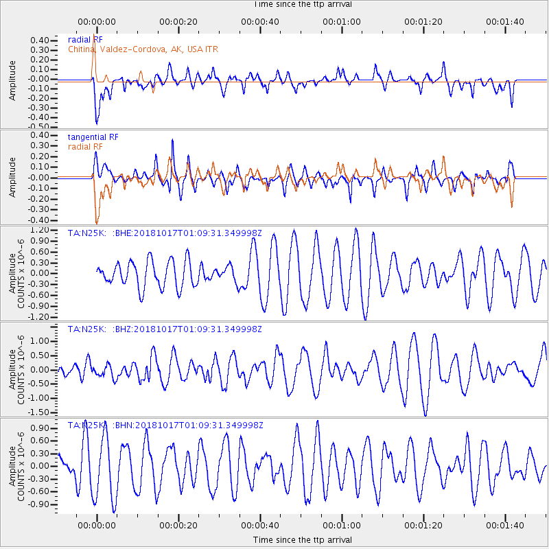
N25K Chitina, Valdez-Cordova, AK, USA - Earthquake Result Viewer
*The percent match for this event was below the threshold and hence no stack was calculated.
| Earthquake location: |
Santa Cruz Islands |
| Earthquake latitude/longitude: |
-11.6/166.2 |
| Earthquake time(UTC): |
2018/10/17 (290) 00:57:44 GMT |
| Earthquake Depth: |
35 km |
| Earthquake Magnitude: |
5.5 Mww |
| Earthquake Catalog/Contributor: |
NEIC PDE/us |
|
| Network: |
TA USArray Transportable Network (new EarthScope stations) |
| Station: |
N25K Chitina, Valdez-Cordova, AK, USA |
| Lat/Lon: |
61.61 N/144.60 W |
| Elevation: |
1087 m |
|
| Distance: |
82.5 deg |
| Az: |
21.391 deg |
| Baz: |
228.384 deg |
| Ray Param: |
$rayparam |
*The percent match for this event was below the threshold and hence was not used in the summary stack. |
|
| Radial Match: |
48.489918 % |
| Radial Bump: |
400 |
| Transverse Match: |
46.711933 % |
| Transverse Bump: |
344 |
| SOD ConfigId: |
13570011 |
| Insert Time: |
2019-05-01 13:50:45.264 +0000 |
| GWidth: |
2.5 |
| Max Bumps: |
400 |
| Tol: |
0.001 |
|
Signal To Noise
| Channel | StoN | STA | LTA |
| TA:N25K: :BHZ:20181017T01:09:31.349998Z | 0.41569707 | 2.2719587E-7 | 5.465419E-7 |
| TA:N25K: :BHN:20181017T01:09:31.349998Z | 1.8485016 | 7.618614E-7 | 4.1215077E-7 |
| TA:N25K: :BHE:20181017T01:09:31.349998Z | 0.6891277 | 2.4444589E-7 | 3.5471783E-7 |
| Arrivals |
| Ps | |
| PpPs | |
| PsPs/PpSs | |


