You are here: Home > Network List > TJ - Tajikistan National Seismic Network Stations List
> Station GARM Garm, Tajikistan > Earthquake Result Viewer
GARM Garm, Tajikistan - Earthquake Result Viewer
*The percent match for this event was below the threshold and hence no stack was calculated.
| Earthquake location: |
Near North Coast Of Irian Jaya |
| Earthquake latitude/longitude: |
-2.8/139.1 |
| Earthquake time(UTC): |
2018/10/19 (292) 05:55:12 GMT |
| Earthquake Depth: |
58 km |
| Earthquake Magnitude: |
5.5 Mww |
| Earthquake Catalog/Contributor: |
NEIC PDE/us |
|
| Network: |
TJ Tajikistan National Seismic Network |
| Station: |
GARM Garm, Tajikistan |
| Lat/Lon: |
39.00 N/70.32 E |
| Elevation: |
1305 m |
|
| Distance: |
75.5 deg |
| Az: |
311.37 deg |
| Baz: |
105.855 deg |
| Ray Param: |
$rayparam |
*The percent match for this event was below the threshold and hence was not used in the summary stack. |
|
| Radial Match: |
64.91053 % |
| Radial Bump: |
400 |
| Transverse Match: |
55.649414 % |
| Transverse Bump: |
400 |
| SOD ConfigId: |
13570011 |
| Insert Time: |
2019-05-01 13:55:23.088 +0000 |
| GWidth: |
2.5 |
| Max Bumps: |
400 |
| Tol: |
0.001 |
|
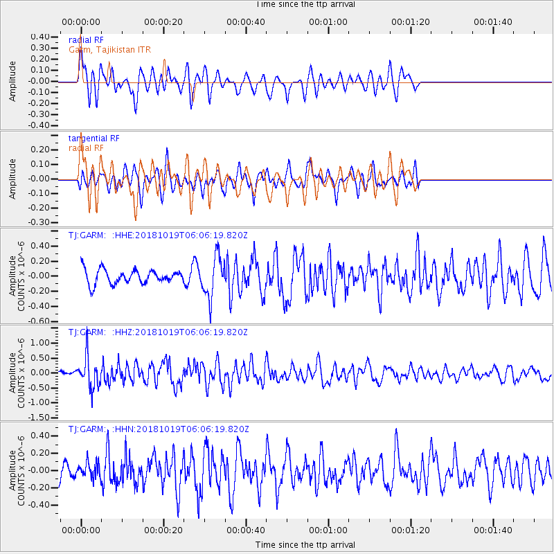
Signal To Noise
| Channel | StoN | STA | LTA |
| TJ:GARM: :HHZ:20181019T06:06:19.820Z | 4.2293854 | 5.200782E-7 | 1.2296779E-7 |
| TJ:GARM: :HHN:20181019T06:06:19.820Z | 0.9982496 | 8.784331E-8 | 8.7997336E-8 |
| TJ:GARM: :HHE:20181019T06:06:19.820Z | 2.9748957 | 2.7752586E-7 | 9.328928E-8 |
| Arrivals |
| Ps | |
| PpPs | |
| PsPs/PpSs | |


