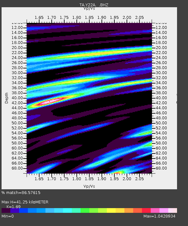
Y22A Socorro, NM, USA - Earthquake Result Viewer
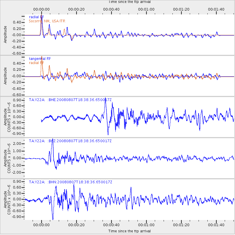
Earthquake location: Andreanof Islands, Aleutian Is.
Earthquake latitude/longitude: 52.2/-175.7
Earthquake time(UTC): 2008/08/07 (220) 18:30:03 GMT
Earthquake Depth: 12 km
Earthquake Magnitude: 5.6 MB, 5.5 MS, 5.8 MW, 5.8 MW
Earthquake Catalog/Contributor: WHDF/NEIC
Network: TA USArray Transportable Network (new EarthScope stations)
Station: Y22A Socorro, NM, USA
Lat/Lon: 33.94 N/106.97 W
Elevation: 1674 m
Distance: 51.4 deg
Az: 82.356 deg
Baz: 312.787 deg
Ray Param: 0.06743692
Estimated Moho Depth: 41.25 km
Estimated Crust Vp/Vs: 1.69
Assumed Crust Vp: 6.502 km/s
Estimated Crust Vs: 3.847 km/s
Estimated Crust Poisson's Ratio: 0.23
Radial Match: 86.57615 %
Radial Bump: 365
Transverse Match: 71.409874 %
Transverse Bump: 400
SOD ConfigId: 2504
Insert Time: 2010-03-06 17:00:56.164 +0000
GWidth: 2.5
Max Bumps: 400
Tol: 0.001

Signal To Noise

ChannelStoNSTALTA
TA:Y22A: :BHZ:20080807T18:38:36.650017Z10.3232944.2640988E-74.1305604E-8
TA:Y22A: :BHN:20080807T18:38:36.650017Z2.38411211.0506618E-74.406931E-8
TA:Y22A: :BHE:20080807T18:38:36.650017Z1.50772441.2259002E-78.130798E-8
Arrivals
Ps4.7 SECOND
PpPs16 SECOND
PsPs/PpSs21 SECOND