You are here: Home > Network List > IC - New China Digital Seismograph Network Stations List
> Station KMI Kunming, Yunnan Province, China > Earthquake Result Viewer
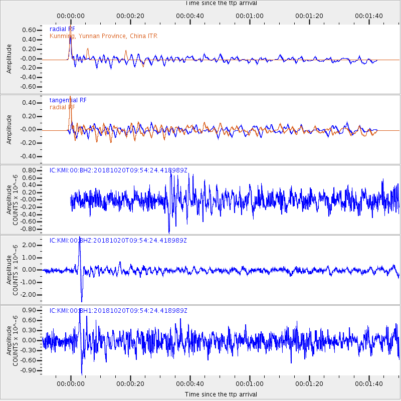
KMI Kunming, Yunnan Province, China - Earthquake Result Viewer
*The percent match for this event was below the threshold and hence no stack was calculated.
| Earthquake location: |
Banda Sea |
| Earthquake latitude/longitude: |
-6.5/128.3 |
| Earthquake time(UTC): |
2018/10/20 (293) 09:47:52 GMT |
| Earthquake Depth: |
352 km |
| Earthquake Magnitude: |
5.5 Mww |
| Earthquake Catalog/Contributor: |
NEIC PDE/us |
|
| Network: |
IC New China Digital Seismograph Network |
| Station: |
KMI Kunming, Yunnan Province, China |
| Lat/Lon: |
25.12 N/102.74 E |
| Elevation: |
1975 m |
|
| Distance: |
40.1 deg |
| Az: |
322.647 deg |
| Baz: |
138.314 deg |
| Ray Param: |
$rayparam |
*The percent match for this event was below the threshold and hence was not used in the summary stack. |
|
| Radial Match: |
77.406235 % |
| Radial Bump: |
400 |
| Transverse Match: |
71.906654 % |
| Transverse Bump: |
400 |
| SOD ConfigId: |
13570011 |
| Insert Time: |
2019-05-01 13:57:27.656 +0000 |
| GWidth: |
2.5 |
| Max Bumps: |
400 |
| Tol: |
0.001 |
|
Signal To Noise
| Channel | StoN | STA | LTA |
| IC:KMI:00:BHZ:20181020T09:54:24.418989Z | 11.297137 | 9.798711E-7 | 8.673623E-8 |
| IC:KMI:00:BH1:20181020T09:54:24.418989Z | 2.3301244 | 3.5909696E-7 | 1.5411065E-7 |
| IC:KMI:00:BH2:20181020T09:54:24.418989Z | 2.4568043 | 3.470871E-7 | 1.4127585E-7 |
| Arrivals |
| Ps | |
| PpPs | |
| PsPs/PpSs | |


