You are here: Home > Network List > TA - USArray Transportable Network (new EarthScope stations) Stations List
> Station K13K Kusilvak Mountain, AK, USA > Earthquake Result Viewer
K13K Kusilvak Mountain, AK, USA - Earthquake Result Viewer
*The percent match for this event was below the threshold and hence no stack was calculated.
| Earthquake location: |
Banda Sea |
| Earthquake latitude/longitude: |
-6.5/128.3 |
| Earthquake time(UTC): |
2018/10/20 (293) 09:47:52 GMT |
| Earthquake Depth: |
352 km |
| Earthquake Magnitude: |
5.5 Mww |
| Earthquake Catalog/Contributor: |
NEIC PDE/us |
|
| Network: |
TA USArray Transportable Network (new EarthScope stations) |
| Station: |
K13K Kusilvak Mountain, AK, USA |
| Lat/Lon: |
61.93 N/164.66 W |
| Elevation: |
204 m |
|
| Distance: |
85.2 deg |
| Az: |
25.924 deg |
| Baz: |
246.704 deg |
| Ray Param: |
$rayparam |
*The percent match for this event was below the threshold and hence was not used in the summary stack. |
|
| Radial Match: |
45.951977 % |
| Radial Bump: |
400 |
| Transverse Match: |
68.94248 % |
| Transverse Bump: |
400 |
| SOD ConfigId: |
13570011 |
| Insert Time: |
2019-05-01 13:58:56.725 +0000 |
| GWidth: |
2.5 |
| Max Bumps: |
400 |
| Tol: |
0.001 |
|
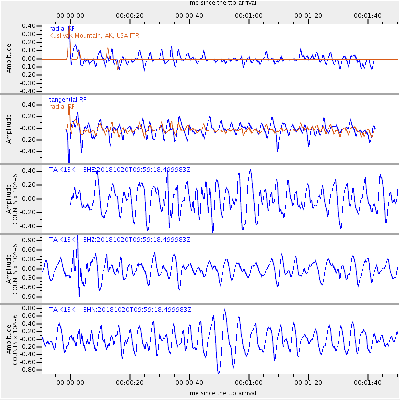
Signal To Noise
| Channel | StoN | STA | LTA |
| TA:K13K: :BHZ:20181020T09:59:18.499983Z | 2.782973 | 4.351953E-7 | 1.5637782E-7 |
| TA:K13K: :BHN:20181020T09:59:18.499983Z | 0.68236095 | 1.2051076E-7 | 1.7660852E-7 |
| TA:K13K: :BHE:20181020T09:59:18.499983Z | 1.2005619 | 1.9451605E-7 | 1.6202085E-7 |
| Arrivals |
| Ps | |
| PpPs | |
| PsPs/PpSs | |


