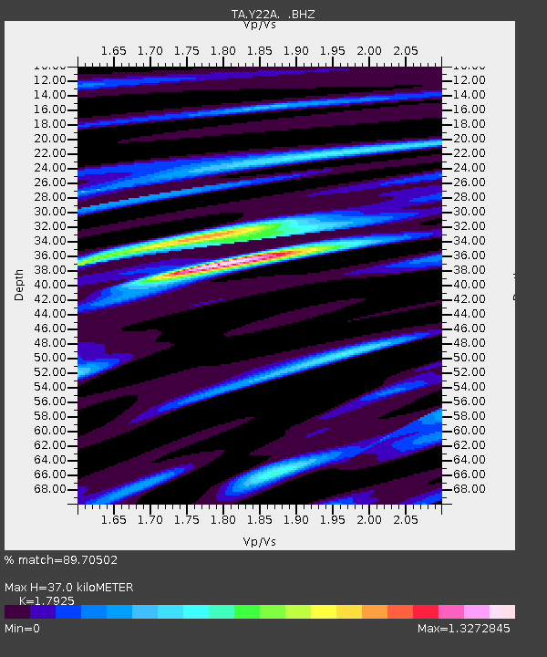
Y22A Socorro, NM, USA - Earthquake Result Viewer
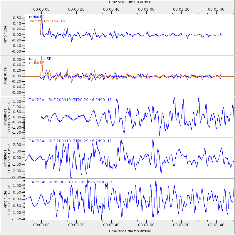
Earthquake location: Fox Islands, Aleutian Islands
Earthquake latitude/longitude: 52.6/-167.1
Earthquake time(UTC): 2009/10/13 (286) 20:21:53 GMT
Earthquake Depth: 14 km
Earthquake Magnitude: 5.9 MB, 6.4 MS, 6.4 MW, 6.4 MW
Earthquake Catalog/Contributor: WHDF/NEIC
Network: TA USArray Transportable Network (new EarthScope stations)
Station: Y22A Socorro, NM, USA
Lat/Lon: 33.94 N/106.97 W
Elevation: 1674 m
Distance: 46.2 deg
Az: 89.125 deg
Baz: 312.819 deg
Ray Param: 0.07081095
Estimated Moho Depth: 37.0 km
Estimated Crust Vp/Vs: 1.79
Assumed Crust Vp: 6.502 km/s
Estimated Crust Vs: 3.627 km/s
Estimated Crust Poisson's Ratio: 0.27
Radial Match: 89.70502 %
Radial Bump: 312
Transverse Match: 75.51472 %
Transverse Bump: 400
SOD ConfigId: 2622
Insert Time: 2010-03-06 17:01:28.054 +0000
GWidth: 2.5
Max Bumps: 400
Tol: 0.001

Signal To Noise

ChannelStoNSTALTA
TA:Y22A: :BHZ:20091013T20:29:46.249011Z2.88218865.234886E-71.8162885E-7
TA:Y22A: :BHN:20091013T20:29:46.249011Z1.02765982.557354E-72.488522E-7
TA:Y22A: :BHE:20091013T20:29:46.249011Z2.37851124.850383E-72.0392517E-7
Arrivals
Ps4.8 SECOND
PpPs15 SECOND
PsPs/PpSs20 SECOND