You are here: Home > Network List > US - United States National Seismic Network Stations List
> Station HAWA Hanford, Washington, USA > Earthquake Result Viewer
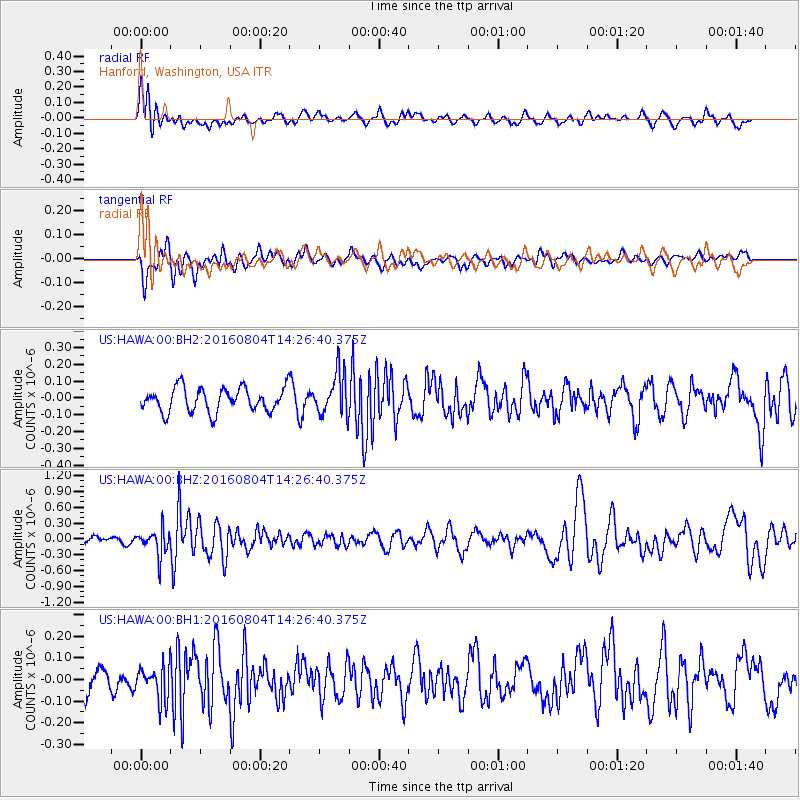
HAWA Hanford, Washington, USA - Earthquake Result Viewer
*The percent match for this event was below the threshold and hence no stack was calculated.
| Earthquake location: |
Jujuy Province, Argentina |
| Earthquake latitude/longitude: |
-22.4/-66.0 |
| Earthquake time(UTC): |
2016/08/04 (217) 14:15:11 GMT |
| Earthquake Depth: |
258 km |
| Earthquake Magnitude: |
6.0 MO |
| Earthquake Catalog/Contributor: |
NEIC PDE/NEIC ALERT |
|
| Network: |
US United States National Seismic Network |
| Station: |
HAWA Hanford, Washington, USA |
| Lat/Lon: |
46.39 N/119.53 W |
| Elevation: |
364 m |
|
| Distance: |
83.8 deg |
| Az: |
325.951 deg |
| Baz: |
131.522 deg |
| Ray Param: |
$rayparam |
*The percent match for this event was below the threshold and hence was not used in the summary stack. |
|
| Radial Match: |
67.40433 % |
| Radial Bump: |
400 |
| Transverse Match: |
44.69726 % |
| Transverse Bump: |
400 |
| SOD ConfigId: |
1634031 |
| Insert Time: |
2016-08-18 14:19:44.172 +0000 |
| GWidth: |
2.5 |
| Max Bumps: |
400 |
| Tol: |
0.001 |
|
Signal To Noise
| Channel | StoN | STA | LTA |
| US:HAWA:00:BHZ:20160804T14:26:40.375Z | 2.8670285 | 2.405642E-7 | 8.390715E-8 |
| US:HAWA:00:BH1:20160804T14:26:40.375Z | 1.4118925 | 7.813674E-8 | 5.5341854E-8 |
| US:HAWA:00:BH2:20160804T14:26:40.375Z | 1.760605 | 1.2532249E-7 | 7.1181496E-8 |
| Arrivals |
| Ps | |
| PpPs | |
| PsPs/PpSs | |


