You are here: Home > Network List > TA - USArray Transportable Network (new EarthScope stations) Stations List
> Station Y22A Socorro, NM, USA > Earthquake Result Viewer
Y22A Socorro, NM, USA - Earthquake Result Viewer
| Earthquake location: |
Sea Of Okhotsk |
| Earthquake latitude/longitude: |
54.2/154.3 |
| Earthquake time(UTC): |
2008/11/24 (329) 09:02:58 GMT |
| Earthquake Depth: |
492 km |
| Earthquake Magnitude: |
6.5 MB, 7.3 MW, 7.3 MW |
| Earthquake Catalog/Contributor: |
WHDF/NEIC |
|
| Network: |
TA USArray Transportable Network (new EarthScope stations) |
| Station: |
Y22A Socorro, NM, USA |
| Lat/Lon: |
33.94 N/106.97 W |
| Elevation: |
1674 m |
|
| Distance: |
67.9 deg |
| Az: |
62.468 deg |
| Baz: |
321.198 deg |
| Ray Param: |
0.05496118 |
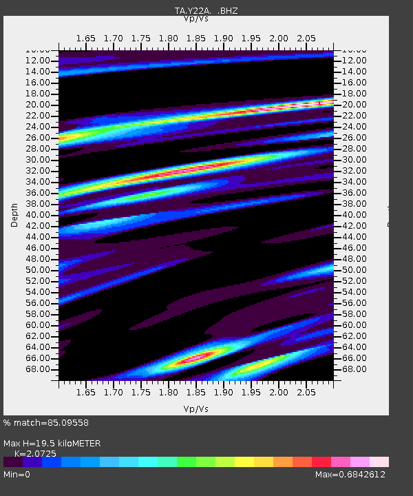
| Estimated Moho Depth: |
19.5 km |
| Estimated Crust Vp/Vs: |
2.07 |
| Assumed Crust Vp: |
6.502 km/s |
| Estimated Crust Vs: |
3.137 km/s |
| Estimated Crust Poisson's Ratio: |
0.35 |
|
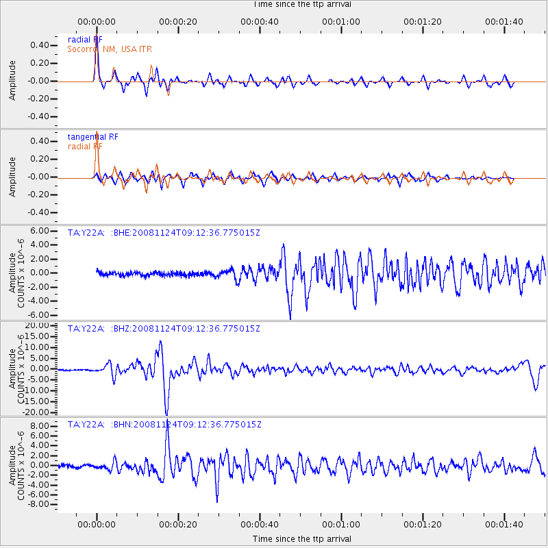
| Radial Match: |
85.09558 % |
| Radial Bump: |
359 |
| Transverse Match: |
60.03085 % |
| Transverse Bump: |
400 |
| SOD ConfigId: |
2658 |
| Insert Time: |
2010-03-06 17:01:31.105 +0000 |
| GWidth: |
2.5 |
| Max Bumps: |
400 |
| Tol: |
0.001 |
|
Signal To Noise
| Channel | StoN | STA | LTA |
| TA:Y22A: :BHZ:20081124T09:12:36.775015Z | 13.990331 | 2.6564144E-6 | 1.8987504E-7 |
| TA:Y22A: :BHN:20081124T09:12:36.775015Z | 4.4240866 | 8.194297E-7 | 1.8522007E-7 |
| TA:Y22A: :BHE:20081124T09:12:36.775015Z | 2.8391097 | 6.844988E-7 | 2.4109627E-7 |
| Arrivals |
| Ps | 3.3 SECOND |
| PpPs | 8.9 SECOND |
| PsPs/PpSs | 12 SECOND |


