You are here: Home > Network List > TS - TERRAscope (Southern California Seismic Network) Stations List
> Station BAR Barrett Dam, California, USA > Earthquake Result Viewer
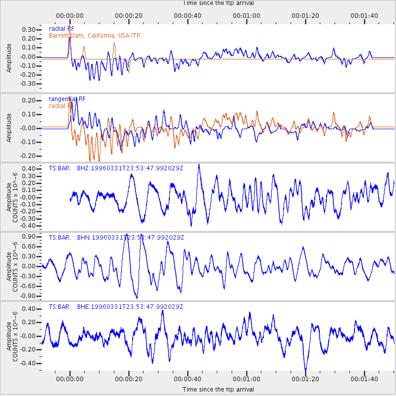
BAR Barrett Dam, California, USA - Earthquake Result Viewer
*The percent match for this event was below the threshold and hence no stack was calculated.
| Earthquake location: |
Santa Cruz Islands |
| Earthquake latitude/longitude: |
-11.2/165.6 |
| Earthquake time(UTC): |
1996/03/31 (091) 23:41:43 GMT |
| Earthquake Depth: |
33 km |
| Earthquake Magnitude: |
5.6 MB, 6.1 MS, 6.0 UNKNOWN, 5.9 MW |
| Earthquake Catalog/Contributor: |
WHDF/NEIC |
|
| Network: |
TS TERRAscope (Southern California Seismic Network) |
| Station: |
BAR Barrett Dam, California, USA |
| Lat/Lon: |
32.68 N/116.67 W |
| Elevation: |
548 m |
|
| Distance: |
85.8 deg |
| Az: |
55.704 deg |
| Baz: |
253.999 deg |
| Ray Param: |
$rayparam |
*The percent match for this event was below the threshold and hence was not used in the summary stack. |
|
| Radial Match: |
64.32377 % |
| Radial Bump: |
400 |
| Transverse Match: |
72.143875 % |
| Transverse Bump: |
400 |
| SOD ConfigId: |
4480 |
| Insert Time: |
2010-02-26 13:59:08.644 +0000 |
| GWidth: |
2.5 |
| Max Bumps: |
400 |
| Tol: |
0.001 |
|
Signal To Noise
| Channel | StoN | STA | LTA |
| TS:BAR: :BHN:19960331T23:53:47.992029Z | 3.0368876 | 2.6293023E-7 | 8.6578844E-8 |
| TS:BAR: :BHE:19960331T23:53:47.992029Z | 0.9231834 | 8.521129E-8 | 9.230158E-8 |
| TS:BAR: :BHZ:19960331T23:53:47.992029Z | 1.0845549 | 1.4283657E-7 | 1.3170063E-7 |
| Arrivals |
| Ps | |
| PpPs | |
| PsPs/PpSs | |


