You are here: Home > Network List > TJ - Tajikistan National Seismic Network Stations List
> Station GARM Garm, Tajikistan > Earthquake Result Viewer
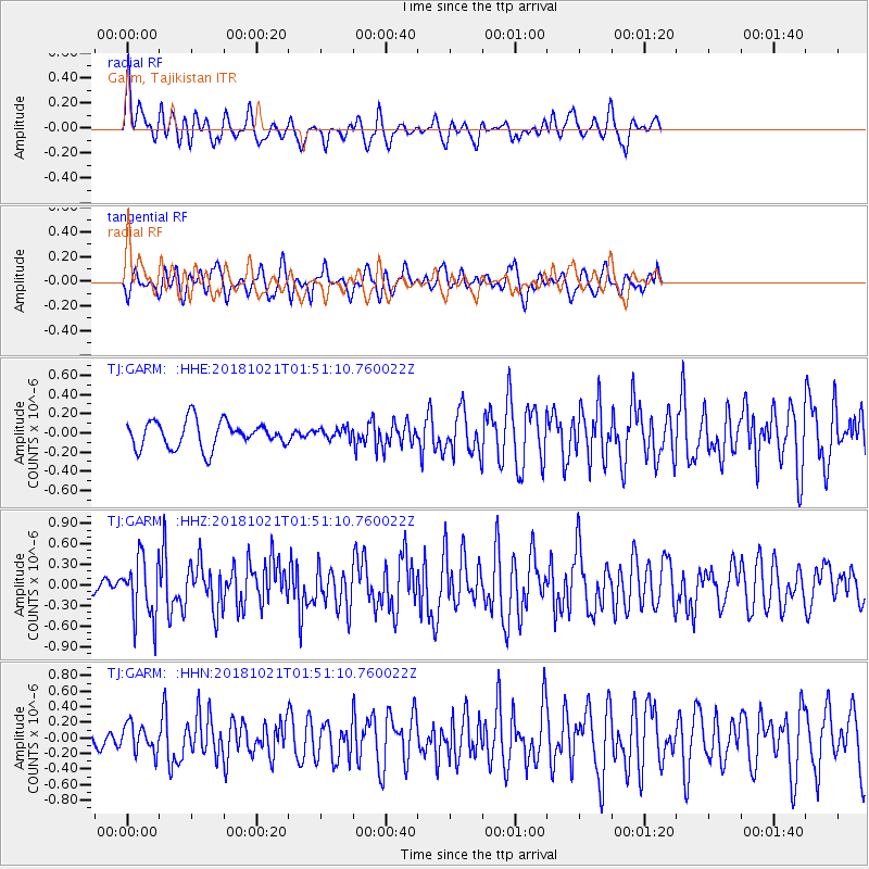
GARM Garm, Tajikistan - Earthquake Result Viewer
*The percent match for this event was below the threshold and hence no stack was calculated.
| Earthquake location: |
Southwest Indian Ridge |
| Earthquake latitude/longitude: |
-29.5/60.7 |
| Earthquake time(UTC): |
2018/10/21 (294) 01:40:37 GMT |
| Earthquake Depth: |
10 km |
| Earthquake Magnitude: |
5.9 Mww |
| Earthquake Catalog/Contributor: |
NEIC PDE/us |
|
| Network: |
TJ Tajikistan National Seismic Network |
| Station: |
GARM Garm, Tajikistan |
| Lat/Lon: |
39.00 N/70.32 E |
| Elevation: |
1305 m |
|
| Distance: |
68.8 deg |
| Az: |
8.025 deg |
| Baz: |
188.984 deg |
| Ray Param: |
$rayparam |
*The percent match for this event was below the threshold and hence was not used in the summary stack. |
|
| Radial Match: |
69.69429 % |
| Radial Bump: |
396 |
| Transverse Match: |
66.727234 % |
| Transverse Bump: |
400 |
| SOD ConfigId: |
13570011 |
| Insert Time: |
2019-05-01 14:02:49.440 +0000 |
| GWidth: |
2.5 |
| Max Bumps: |
400 |
| Tol: |
0.001 |
|
Signal To Noise
| Channel | StoN | STA | LTA |
| TJ:GARM: :HHZ:20181021T01:51:10.760022Z | 3.237024 | 4.4332415E-7 | 1.3695423E-7 |
| TJ:GARM: :HHN:20181021T01:51:10.760022Z | 1.545684 | 1.7806394E-7 | 1.1520074E-7 |
| TJ:GARM: :HHE:20181021T01:51:10.760022Z | 0.40170372 | 5.54131E-8 | 1.3794521E-7 |
| Arrivals |
| Ps | |
| PpPs | |
| PsPs/PpSs | |


