You are here: Home > Network List > TJ - Tajikistan National Seismic Network Stations List
> Station CHGR Chuyangaron, Tajikistan > Earthquake Result Viewer
CHGR Chuyangaron, Tajikistan - Earthquake Result Viewer
| Earthquake location: |
Southwest Indian Ridge |
| Earthquake latitude/longitude: |
-29.5/60.7 |
| Earthquake time(UTC): |
2018/10/21 (294) 01:40:37 GMT |
| Earthquake Depth: |
10 km |
| Earthquake Magnitude: |
5.9 Mww |
| Earthquake Catalog/Contributor: |
NEIC PDE/us |
|
| Network: |
TJ Tajikistan National Seismic Network |
| Station: |
CHGR Chuyangaron, Tajikistan |
| Lat/Lon: |
38.66 N/69.16 E |
| Elevation: |
1049 m |
|
| Distance: |
68.3 deg |
| Az: |
7.118 deg |
| Baz: |
187.929 deg |
| Ray Param: |
0.056401815 |
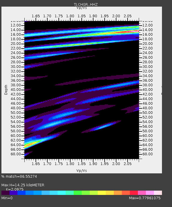
| Estimated Moho Depth: |
14.25 km |
| Estimated Crust Vp/Vs: |
2.10 |
| Assumed Crust Vp: |
6.483 km/s |
| Estimated Crust Vs: |
3.091 km/s |
| Estimated Crust Poisson's Ratio: |
0.35 |
|
| Radial Match: |
86.55274 % |
| Radial Bump: |
400 |
| Transverse Match: |
74.836006 % |
| Transverse Bump: |
400 |
| SOD ConfigId: |
13570011 |
| Insert Time: |
2019-05-01 14:02:50.699 +0000 |
| GWidth: |
2.5 |
| Max Bumps: |
400 |
| Tol: |
0.001 |
|

Signal To Noise
| Channel | StoN | STA | LTA |
| TJ:CHGR: :HHZ:20181021T01:51:07.82002Z | 6.446496 | 1.0146821E-6 | 1.5740056E-7 |
| TJ:CHGR: :HHN:20181021T01:51:07.82002Z | 3.7557163 | 5.1436746E-7 | 1.3695589E-7 |
| TJ:CHGR: :HHE:20181021T01:51:07.82002Z | 1.0066985 | 1.1979303E-7 | 1.18995935E-7 |
| Arrivals |
| Ps | 2.5 SECOND |
| PpPs | 6.6 SECOND |
| PsPs/PpSs | 9.1 SECOND |


