You are here: Home > Network List > CN - Canadian National Seismograph Network Stations List
> Station PAPH Port au Prince, Haiti, > Earthquake Result Viewer
PAPH Port au Prince, Haiti, - Earthquake Result Viewer
| Earthquake location: |
Vancouver Island, Canada Region |
| Earthquake latitude/longitude: |
49.1/-129.7 |
| Earthquake time(UTC): |
2018/10/22 (295) 05:39:39 GMT |
| Earthquake Depth: |
11 km |
| Earthquake Magnitude: |
6.6 Mi |
| Earthquake Catalog/Contributor: |
NEIC PDE/at |
|
| Network: |
CN Canadian National Seismograph Network |
| Station: |
PAPH Port au Prince, Haiti, |
| Lat/Lon: |
18.52 N/72.30 W |
| Elevation: |
218 m |
|
| Distance: |
55.0 deg |
| Az: |
102.528 deg |
| Baz: |
317.492 deg |
| Ray Param: |
0.06507773 |
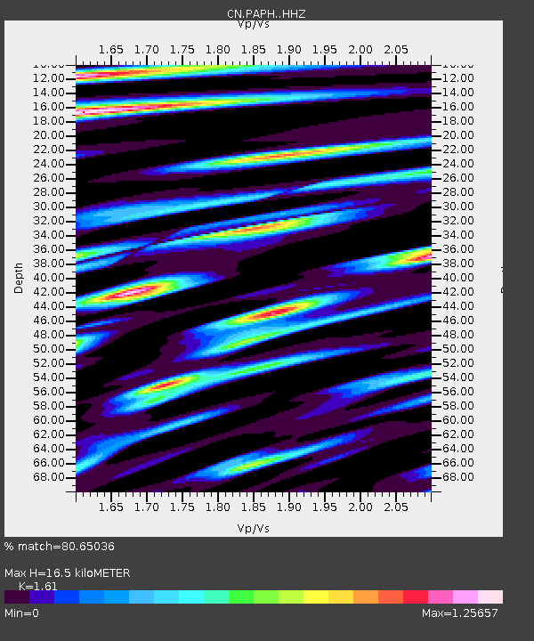
| Estimated Moho Depth: |
16.5 km |
| Estimated Crust Vp/Vs: |
1.61 |
| Assumed Crust Vp: |
5.14 km/s |
| Estimated Crust Vs: |
3.193 km/s |
| Estimated Crust Poisson's Ratio: |
0.19 |
|
| Radial Match: |
80.65036 % |
| Radial Bump: |
400 |
| Transverse Match: |
75.60451 % |
| Transverse Bump: |
400 |
| SOD ConfigId: |
13570011 |
| Insert Time: |
2019-05-01 14:04:31.111 +0000 |
| GWidth: |
2.5 |
| Max Bumps: |
400 |
| Tol: |
0.001 |
|

Signal To Noise
| Channel | StoN | STA | LTA |
| CN:PAPH: :HHZ:20181022T05:48:39.570007Z | 2.7632551 | 6.303723E-7 | 2.2812671E-7 |
| CN:PAPH: :HHN:20181022T05:48:39.570007Z | 0.6838202 | 2.2946098E-7 | 3.3555747E-7 |
| CN:PAPH: :HHE:20181022T05:48:39.570007Z | 1.2115057 | 2.9641387E-7 | 2.446657E-7 |
| Arrivals |
| Ps | 2.0 SECOND |
| PpPs | 8.1 SECOND |
| PsPs/PpSs | 10 SECOND |


