You are here: Home > Network List > TA - USArray Transportable Network (new EarthScope stations) Stations List
> Station Y22A Socorro, NM, USA > Earthquake Result Viewer
Y22A Socorro, NM, USA - Earthquake Result Viewer
| Earthquake location: |
Iceland |
| Earthquake latitude/longitude: |
64.0/-21.0 |
| Earthquake time(UTC): |
2008/05/29 (150) 15:46:00 GMT |
| Earthquake Depth: |
10 km |
| Earthquake Magnitude: |
6.0 MB, 6.2 MS, 6.3 MW, 6.2 MW |
| Earthquake Catalog/Contributor: |
WHDF/NEIC |
|
| Network: |
TA USArray Transportable Network (new EarthScope stations) |
| Station: |
Y22A Socorro, NM, USA |
| Lat/Lon: |
33.94 N/106.97 W |
| Elevation: |
1674 m |
|
| Distance: |
58.4 deg |
| Az: |
283.05 deg |
| Baz: |
31.09 deg |
| Ray Param: |
0.06289992 |
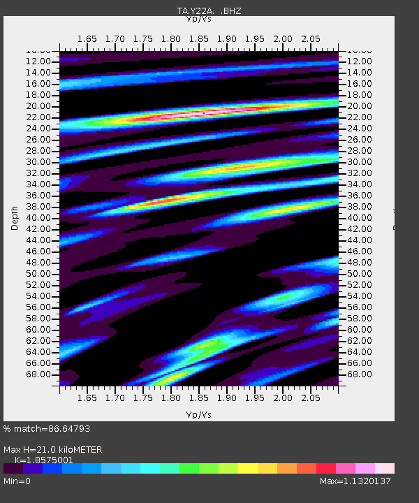
| Estimated Moho Depth: |
21.0 km |
| Estimated Crust Vp/Vs: |
1.86 |
| Assumed Crust Vp: |
6.502 km/s |
| Estimated Crust Vs: |
3.5 km/s |
| Estimated Crust Poisson's Ratio: |
0.30 |
|
| Radial Match: |
86.64793 % |
| Radial Bump: |
391 |
| Transverse Match: |
72.44364 % |
| Transverse Bump: |
400 |
| SOD ConfigId: |
2504 |
| Insert Time: |
2010-03-06 17:01:49.326 +0000 |
| GWidth: |
2.5 |
| Max Bumps: |
400 |
| Tol: |
0.001 |
|
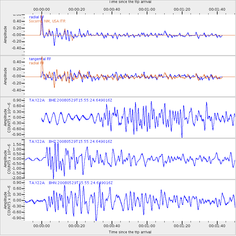
Signal To Noise
| Channel | StoN | STA | LTA |
| TA:Y22A: :BHZ:20080529T15:55:24.649016Z | 8.325372 | 5.4068215E-7 | 6.4943904E-8 |
| TA:Y22A: :BHN:20080529T15:55:24.649016Z | 3.3028646 | 1.9187321E-7 | 5.8092972E-8 |
| TA:Y22A: :BHE:20080529T15:55:24.649016Z | 1.1664051 | 1.8563986E-7 | 1.5915558E-7 |
| Arrivals |
| Ps | 2.9 SECOND |
| PpPs | 8.8 SECOND |
| PsPs/PpSs | 12 SECOND |


