You are here: Home > Network List > N4 - Central and EAstern US Network Stations List
> Station N47A Urbana, IN, USA > Earthquake Result Viewer
N47A Urbana, IN, USA - Earthquake Result Viewer
| Earthquake location: |
Vancouver Island, Canada Region |
| Earthquake latitude/longitude: |
49.1/-129.7 |
| Earthquake time(UTC): |
2018/10/22 (295) 05:39:39 GMT |
| Earthquake Depth: |
11 km |
| Earthquake Magnitude: |
6.6 Mi |
| Earthquake Catalog/Contributor: |
NEIC PDE/at |
|
| Network: |
N4 Central and EAstern US Network |
| Station: |
N47A Urbana, IN, USA |
| Lat/Lon: |
40.88 N/85.69 W |
| Elevation: |
252 m |
|
| Distance: |
31.8 deg |
| Az: |
88.133 deg |
| Baz: |
300.038 deg |
| Ray Param: |
0.07890743 |
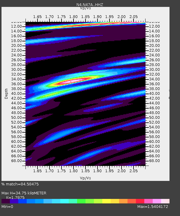
| Estimated Moho Depth: |
34.75 km |
| Estimated Crust Vp/Vs: |
1.79 |
| Assumed Crust Vp: |
6.498 km/s |
| Estimated Crust Vs: |
3.635 km/s |
| Estimated Crust Poisson's Ratio: |
0.27 |
|
| Radial Match: |
84.58475 % |
| Radial Bump: |
283 |
| Transverse Match: |
66.26139 % |
| Transverse Bump: |
400 |
| SOD ConfigId: |
13570011 |
| Insert Time: |
2019-05-01 14:06:37.136 +0000 |
| GWidth: |
2.5 |
| Max Bumps: |
400 |
| Tol: |
0.001 |
|

Signal To Noise
| Channel | StoN | STA | LTA |
| N4:N47A: :HHZ:20181022T05:45:32.820007Z | 2.9144475 | 1.330233E-6 | 4.5642716E-7 |
| N4:N47A: :HHN:20181022T05:45:32.820007Z | 1.5311029 | 4.4877612E-7 | 2.9310644E-7 |
| N4:N47A: :HHE:20181022T05:45:32.820007Z | 1.8465883 | 7.077757E-7 | 3.832883E-7 |
| Arrivals |
| Ps | 4.6 SECOND |
| PpPs | 14 SECOND |
| PsPs/PpSs | 18 SECOND |


