You are here: Home > Network List > N4 - Central and EAstern US Network Stations List
> Station U56A King, NC, USA > Earthquake Result Viewer
U56A King, NC, USA - Earthquake Result Viewer
| Earthquake location: |
Vancouver Island, Canada Region |
| Earthquake latitude/longitude: |
49.1/-129.7 |
| Earthquake time(UTC): |
2018/10/22 (295) 05:39:39 GMT |
| Earthquake Depth: |
11 km |
| Earthquake Magnitude: |
6.6 Mi |
| Earthquake Catalog/Contributor: |
NEIC PDE/at |
|
| Network: |
N4 Central and EAstern US Network |
| Station: |
U56A King, NC, USA |
| Lat/Lon: |
36.35 N/80.38 W |
| Elevation: |
363 m |
|
| Distance: |
37.8 deg |
| Az: |
90.842 deg |
| Baz: |
305.57 deg |
| Ray Param: |
0.07593959 |
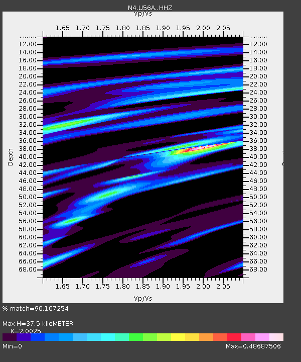
| Estimated Moho Depth: |
37.5 km |
| Estimated Crust Vp/Vs: |
2.00 |
| Assumed Crust Vp: |
6.159 km/s |
| Estimated Crust Vs: |
3.076 km/s |
| Estimated Crust Poisson's Ratio: |
0.33 |
|
| Radial Match: |
90.107254 % |
| Radial Bump: |
214 |
| Transverse Match: |
54.633472 % |
| Transverse Bump: |
400 |
| SOD ConfigId: |
13570011 |
| Insert Time: |
2019-05-01 14:06:56.279 +0000 |
| GWidth: |
2.5 |
| Max Bumps: |
400 |
| Tol: |
0.001 |
|

Signal To Noise
| Channel | StoN | STA | LTA |
| N4:U56A: :HHZ:20181022T05:46:24.149994Z | 3.08118 | 8.673817E-7 | 2.8150956E-7 |
| N4:U56A: :HHN:20181022T05:46:24.149994Z | 1.7337141 | 4.3906303E-7 | 2.5324996E-7 |
| N4:U56A: :HHE:20181022T05:46:24.149994Z | 2.582534 | 6.5086795E-7 | 2.5202687E-7 |
| Arrivals |
| Ps | 6.5 SECOND |
| PpPs | 17 SECOND |
| PsPs/PpSs | 24 SECOND |


