You are here: Home > Network List > N4 - Central and EAstern US Network Stations List
> Station Y49A Blount Mountain, AL, USA > Earthquake Result Viewer
Y49A Blount Mountain, AL, USA - Earthquake Result Viewer
| Earthquake location: |
Vancouver Island, Canada Region |
| Earthquake latitude/longitude: |
49.1/-129.7 |
| Earthquake time(UTC): |
2018/10/22 (295) 05:39:39 GMT |
| Earthquake Depth: |
11 km |
| Earthquake Magnitude: |
6.6 Mi |
| Earthquake Catalog/Contributor: |
NEIC PDE/at |
|
| Network: |
N4 Central and EAstern US Network |
| Station: |
Y49A Blount Mountain, AL, USA |
| Lat/Lon: |
33.86 N/86.41 W |
| Elevation: |
362 m |
|
| Distance: |
35.3 deg |
| Az: |
99.18 deg |
| Baz: |
308.819 deg |
| Ray Param: |
0.07727404 |
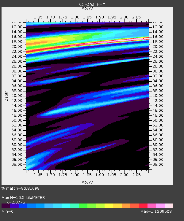
| Estimated Moho Depth: |
16.5 km |
| Estimated Crust Vp/Vs: |
2.08 |
| Assumed Crust Vp: |
6.565 km/s |
| Estimated Crust Vs: |
3.16 km/s |
| Estimated Crust Poisson's Ratio: |
0.35 |
|
| Radial Match: |
80.81698 % |
| Radial Bump: |
277 |
| Transverse Match: |
69.69835 % |
| Transverse Bump: |
371 |
| SOD ConfigId: |
13570011 |
| Insert Time: |
2019-05-01 14:07:05.351 +0000 |
| GWidth: |
2.5 |
| Max Bumps: |
400 |
| Tol: |
0.001 |
|

Signal To Noise
| Channel | StoN | STA | LTA |
| N4:Y49A: :HHZ:20181022T05:46:03.48999Z | 2.0465124 | 8.890905E-7 | 4.344418E-7 |
| N4:Y49A: :HHN:20181022T05:46:03.48999Z | 2.104266 | 5.8747025E-7 | 2.791806E-7 |
| N4:Y49A: :HHE:20181022T05:46:03.48999Z | 1.8751771 | 5.7827907E-7 | 3.0838638E-7 |
| Arrivals |
| Ps | 2.9 SECOND |
| PpPs | 7.2 SECOND |
| PsPs/PpSs | 10 SECOND |


