You are here: Home > Network List > N4 - Central and EAstern US Network Stations List
> Station Y57A Sumter, SC, USA > Earthquake Result Viewer
Y57A Sumter, SC, USA - Earthquake Result Viewer
| Earthquake location: |
Vancouver Island, Canada Region |
| Earthquake latitude/longitude: |
49.1/-129.7 |
| Earthquake time(UTC): |
2018/10/22 (295) 05:39:39 GMT |
| Earthquake Depth: |
11 km |
| Earthquake Magnitude: |
6.6 Mi |
| Earthquake Catalog/Contributor: |
NEIC PDE/at |
|
| Network: |
N4 Central and EAstern US Network |
| Station: |
Y57A Sumter, SC, USA |
| Lat/Lon: |
34.02 N/80.39 W |
| Elevation: |
56 m |
|
| Distance: |
39.2 deg |
| Az: |
93.843 deg |
| Baz: |
307.915 deg |
| Ray Param: |
0.07513834 |
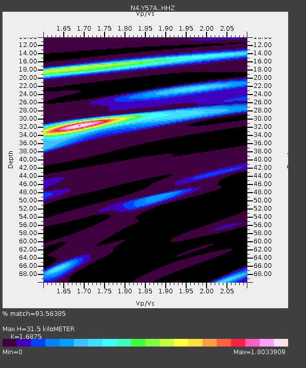
| Estimated Moho Depth: |
31.5 km |
| Estimated Crust Vp/Vs: |
1.69 |
| Assumed Crust Vp: |
6.419 km/s |
| Estimated Crust Vs: |
3.804 km/s |
| Estimated Crust Poisson's Ratio: |
0.23 |
|
| Radial Match: |
93.56385 % |
| Radial Bump: |
341 |
| Transverse Match: |
55.2393 % |
| Transverse Bump: |
400 |
| SOD ConfigId: |
13570011 |
| Insert Time: |
2019-05-01 14:07:06.482 +0000 |
| GWidth: |
2.5 |
| Max Bumps: |
400 |
| Tol: |
0.001 |
|

Signal To Noise
| Channel | StoN | STA | LTA |
| N4:Y57A: :HHZ:20181022T05:46:35.850006Z | 3.853104 | 9.860358E-7 | 2.5590688E-7 |
| N4:Y57A: :HHN:20181022T05:46:35.850006Z | 1.3856022 | 4.0589543E-7 | 2.9293793E-7 |
| N4:Y57A: :HHE:20181022T05:46:35.850006Z | 2.1868029 | 6.611266E-7 | 3.0232567E-7 |
| Arrivals |
| Ps | 3.6 SECOND |
| PpPs | 12 SECOND |
| PsPs/PpSs | 16 SECOND |


