You are here: Home > Network List > TS - TERRAscope (Southern California Seismic Network) Stations List
> Station BAR Barrett Dam, California, USA > Earthquake Result Viewer
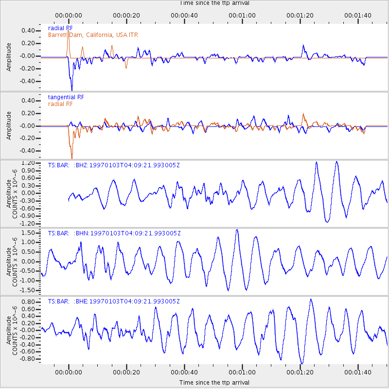
BAR Barrett Dam, California, USA - Earthquake Result Viewer
*The percent match for this event was below the threshold and hence no stack was calculated.
| Earthquake location: |
Tonga Islands |
| Earthquake latitude/longitude: |
-19.2/-174.8 |
| Earthquake time(UTC): |
1997/01/03 (003) 03:58:22 GMT |
| Earthquake Depth: |
140 km |
| Earthquake Magnitude: |
5.7 MB, 6.0 UNKNOWN, 6.0 MW |
| Earthquake Catalog/Contributor: |
WHDF/NEIC |
|
| Network: |
TS TERRAscope (Southern California Seismic Network) |
| Station: |
BAR Barrett Dam, California, USA |
| Lat/Lon: |
32.68 N/116.67 W |
| Elevation: |
548 m |
|
| Distance: |
75.9 deg |
| Az: |
47.638 deg |
| Baz: |
235.884 deg |
| Ray Param: |
$rayparam |
*The percent match for this event was below the threshold and hence was not used in the summary stack. |
|
| Radial Match: |
85.96084 % |
| Radial Bump: |
400 |
| Transverse Match: |
53.204926 % |
| Transverse Bump: |
400 |
| SOD ConfigId: |
4480 |
| Insert Time: |
2010-02-26 13:59:09.806 +0000 |
| GWidth: |
2.5 |
| Max Bumps: |
400 |
| Tol: |
0.001 |
|
Signal To Noise
| Channel | StoN | STA | LTA |
| TS:BAR: :BHN:19970103T04:09:21.993005Z | 0.7331083 | 4.0970795E-7 | 5.5886414E-7 |
| TS:BAR: :BHE:19970103T04:09:21.993005Z | 0.7260785 | 2.1747367E-7 | 2.9951812E-7 |
| TS:BAR: :BHZ:19970103T04:09:21.993005Z | 0.80727625 | 2.2577854E-7 | 2.796794E-7 |
| Arrivals |
| Ps | |
| PpPs | |
| PsPs/PpSs | |


