You are here: Home > Network List > TA - USArray Transportable Network (new EarthScope stations) Stations List
> Station P49A Miami Univ. Ecology Research Center, OH, USA > Earthquake Result Viewer
P49A Miami Univ. Ecology Research Center, OH, USA - Earthquake Result Viewer
| Earthquake location: |
Vancouver Island, Canada Region |
| Earthquake latitude/longitude: |
49.1/-129.7 |
| Earthquake time(UTC): |
2018/10/22 (295) 05:39:39 GMT |
| Earthquake Depth: |
11 km |
| Earthquake Magnitude: |
6.6 Mi |
| Earthquake Catalog/Contributor: |
NEIC PDE/at |
|
| Network: |
TA USArray Transportable Network (new EarthScope stations) |
| Station: |
P49A Miami Univ. Ecology Research Center, OH, USA |
| Lat/Lon: |
39.53 N/84.72 W |
| Elevation: |
272 m |
|
| Distance: |
33.2 deg |
| Az: |
89.562 deg |
| Baz: |
301.872 deg |
| Ray Param: |
0.07833075 |
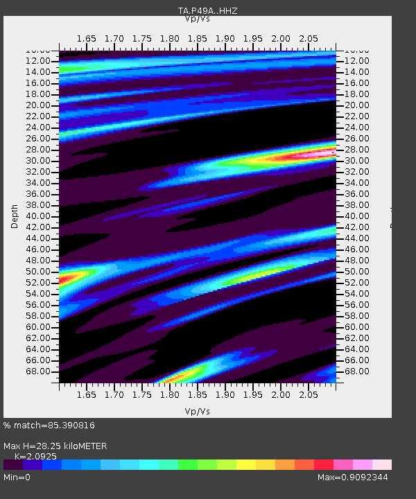
| Estimated Moho Depth: |
28.25 km |
| Estimated Crust Vp/Vs: |
2.09 |
| Assumed Crust Vp: |
6.498 km/s |
| Estimated Crust Vs: |
3.105 km/s |
| Estimated Crust Poisson's Ratio: |
0.35 |
|
| Radial Match: |
85.390816 % |
| Radial Bump: |
355 |
| Transverse Match: |
74.49837 % |
| Transverse Bump: |
400 |
| SOD ConfigId: |
13570011 |
| Insert Time: |
2019-05-01 14:08:20.445 +0000 |
| GWidth: |
2.5 |
| Max Bumps: |
400 |
| Tol: |
0.001 |
|

Signal To Noise
| Channel | StoN | STA | LTA |
| TA:P49A: :HHZ:20181022T05:45:44.51001Z | 2.459695 | 1.3678865E-6 | 5.5612037E-7 |
| TA:P49A: :HHN:20181022T05:45:44.51001Z | 1.7410303 | 6.601074E-7 | 3.7914756E-7 |
| TA:P49A: :HHE:20181022T05:45:44.51001Z | 3.336105 | 9.822403E-7 | 2.9442728E-7 |
| Arrivals |
| Ps | 5.1 SECOND |
| PpPs | 13 SECOND |
| PsPs/PpSs | 18 SECOND |


