You are here: Home > Network List > TA - USArray Transportable Network (new EarthScope stations) Stations List
> Station Y22A Socorro, NM, USA > Earthquake Result Viewer
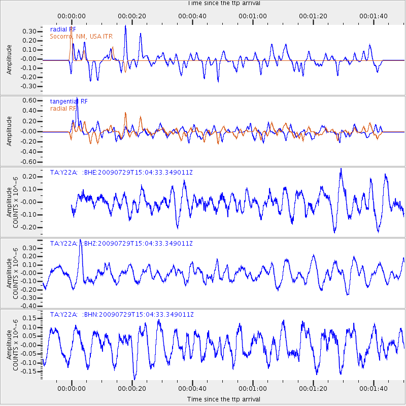
Y22A Socorro, NM, USA - Earthquake Result Viewer
*The percent match for this event was below the threshold and hence no stack was calculated.
| Earthquake location: |
Volcano Islands, Japan Region |
| Earthquake latitude/longitude: |
22.6/143.3 |
| Earthquake time(UTC): |
2009/07/29 (210) 14:52:08 GMT |
| Earthquake Depth: |
140 km |
| Earthquake Magnitude: |
5.5 MW, 5.2 MB, 5.4 MW |
| Earthquake Catalog/Contributor: |
WHDF/NEIC |
|
| Network: |
TA USArray Transportable Network (new EarthScope stations) |
| Station: |
Y22A Socorro, NM, USA |
| Lat/Lon: |
33.94 N/106.97 W |
| Elevation: |
1674 m |
|
| Distance: |
92.7 deg |
| Az: |
51.561 deg |
| Baz: |
299.447 deg |
| Ray Param: |
$rayparam |
*The percent match for this event was below the threshold and hence was not used in the summary stack. |
|
| Radial Match: |
61.153103 % |
| Radial Bump: |
400 |
| Transverse Match: |
72.3112 % |
| Transverse Bump: |
400 |
| SOD ConfigId: |
2622 |
| Insert Time: |
2010-03-06 17:02:26.119 +0000 |
| GWidth: |
2.5 |
| Max Bumps: |
400 |
| Tol: |
0.001 |
|
Signal To Noise
| Channel | StoN | STA | LTA |
| TA:Y22A: :BHZ:20090729T15:04:33.349011Z | 2.0249517 | 1.8059471E-7 | 8.9184695E-8 |
| TA:Y22A: :BHN:20090729T15:04:33.349011Z | 0.7546158 | 6.469065E-8 | 8.572661E-8 |
| TA:Y22A: :BHE:20090729T15:04:33.349011Z | 1.2205878 | 6.5347635E-8 | 5.3537843E-8 |
| Arrivals |
| Ps | |
| PpPs | |
| PsPs/PpSs | |


