You are here: Home > Network List > TA - USArray Transportable Network (new EarthScope stations) Stations List
> Station Y22A Socorro, NM, USA > Earthquake Result Viewer
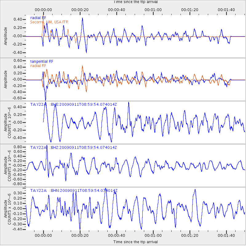
Y22A Socorro, NM, USA - Earthquake Result Viewer
*The percent match for this event was below the threshold and hence no stack was calculated.
| Earthquake location: |
Kuril Islands |
| Earthquake latitude/longitude: |
48.3/154.2 |
| Earthquake time(UTC): |
2009/09/11 (254) 08:49:11 GMT |
| Earthquake Depth: |
35 km |
| Earthquake Magnitude: |
5.8 MB, 5.0 MS, 5.6 MW, 5.6 MW |
| Earthquake Catalog/Contributor: |
WHDF/NEIC |
|
| Network: |
TA USArray Transportable Network (new EarthScope stations) |
| Station: |
Y22A Socorro, NM, USA |
| Lat/Lon: |
33.94 N/106.97 W |
| Elevation: |
1674 m |
|
| Distance: |
70.8 deg |
| Az: |
60.448 deg |
| Baz: |
315.674 deg |
| Ray Param: |
$rayparam |
*The percent match for this event was below the threshold and hence was not used in the summary stack. |
|
| Radial Match: |
61.519726 % |
| Radial Bump: |
400 |
| Transverse Match: |
53.407764 % |
| Transverse Bump: |
400 |
| SOD ConfigId: |
2622 |
| Insert Time: |
2010-03-06 17:02:35.337 +0000 |
| GWidth: |
2.5 |
| Max Bumps: |
400 |
| Tol: |
0.001 |
|
Signal To Noise
| Channel | StoN | STA | LTA |
| TA:Y22A: :BHZ:20090911T08:59:54.074014Z | 1.9687631 | 3.1849615E-7 | 1.6177475E-7 |
| TA:Y22A: :BHN:20090911T08:59:54.074014Z | 0.4328504 | 1.1206807E-7 | 2.5890716E-7 |
| TA:Y22A: :BHE:20090911T08:59:54.074014Z | 1.2440231 | 2.9462183E-7 | 2.3682986E-7 |
| Arrivals |
| Ps | |
| PpPs | |
| PsPs/PpSs | |


