You are here: Home > Network List > TS - TERRAscope (Southern California Seismic Network) Stations List
> Station BAR Barrett Dam, California, USA > Earthquake Result Viewer
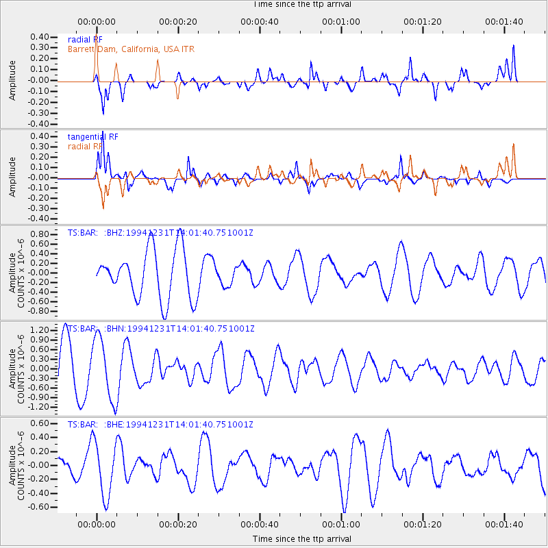
BAR Barrett Dam, California, USA - Earthquake Result Viewer
*The percent match for this event was below the threshold and hence no stack was calculated.
| Earthquake location: |
Near East Coast Of Honshu, Japan |
| Earthquake latitude/longitude: |
40.2/142.7 |
| Earthquake time(UTC): |
1994/12/31 (365) 13:50:22 GMT |
| Earthquake Depth: |
33 km |
| Earthquake Magnitude: |
5.6 MB, 5.6 MS |
| Earthquake Catalog/Contributor: |
WHDF/NEIC |
|
| Network: |
TS TERRAscope (Southern California Seismic Network) |
| Station: |
BAR Barrett Dam, California, USA |
| Lat/Lon: |
32.68 N/116.67 W |
| Elevation: |
548 m |
|
| Distance: |
77.0 deg |
| Az: |
58.291 deg |
| Baz: |
309.395 deg |
| Ray Param: |
$rayparam |
*The percent match for this event was below the threshold and hence was not used in the summary stack. |
|
| Radial Match: |
54.834404 % |
| Radial Bump: |
400 |
| Transverse Match: |
84.92947 % |
| Transverse Bump: |
400 |
| SOD ConfigId: |
4480 |
| Insert Time: |
2010-02-26 13:59:14.170 +0000 |
| GWidth: |
2.5 |
| Max Bumps: |
400 |
| Tol: |
0.001 |
|
Signal To Noise
| Channel | StoN | STA | LTA |
| TS:BAR: :BHN:19941231T14:01:40.751001Z | 1.5862411 | 9.800032E-7 | 6.1781475E-7 |
| TS:BAR: :BHE:19941231T14:01:40.751001Z | 1.5537193 | 3.9097677E-7 | 2.5163925E-7 |
| TS:BAR: :BHZ:19941231T14:01:40.751001Z | 0.38985828 | 1.9348008E-7 | 4.962831E-7 |
| Arrivals |
| Ps | |
| PpPs | |
| PsPs/PpSs | |


