You are here: Home > Network List > TA - USArray Transportable Network (new EarthScope stations) Stations List
> Station Y22A Socorro, NM, USA > Earthquake Result Viewer
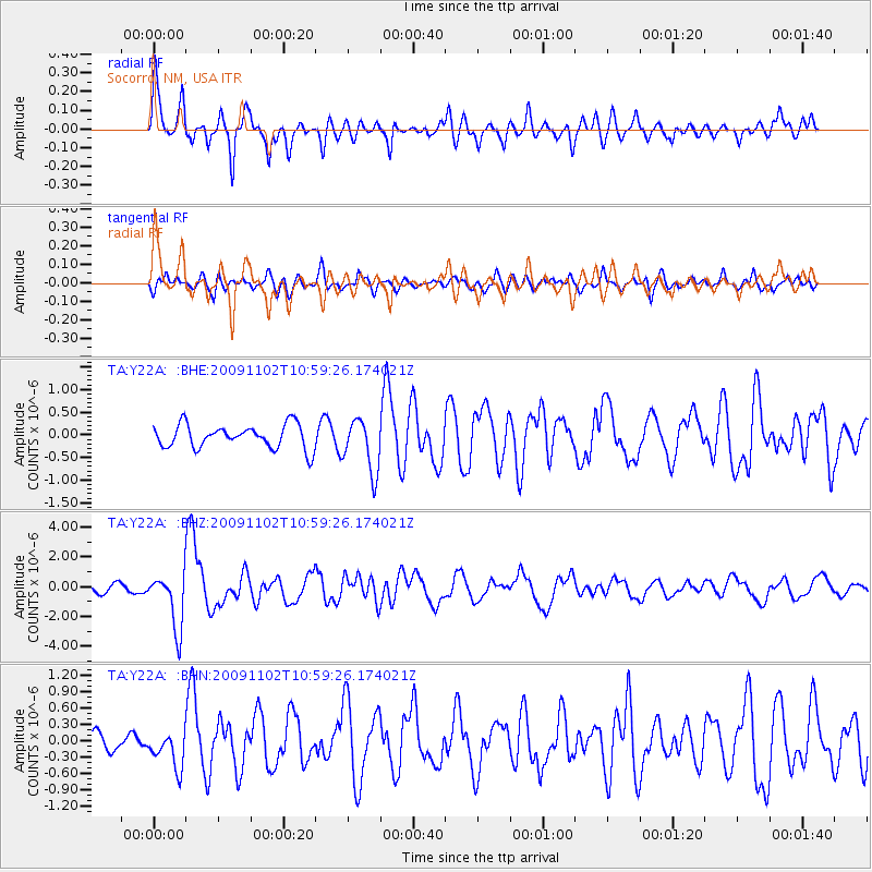
Y22A Socorro, NM, USA - Earthquake Result Viewer
*The percent match for this event was below the threshold and hence no stack was calculated.
| Earthquake location: |
South Of Tonga Islands |
| Earthquake latitude/longitude: |
-24.1/-175.2 |
| Earthquake time(UTC): |
2009/11/02 (306) 10:47:13 GMT |
| Earthquake Depth: |
9.0 km |
| Earthquake Magnitude: |
6.1 MB, 6.1 MS, 6.2 MW, 6.1 MW |
| Earthquake Catalog/Contributor: |
WHDF/NEIC |
|
| Network: |
TA USArray Transportable Network (new EarthScope stations) |
| Station: |
Y22A Socorro, NM, USA |
| Lat/Lon: |
33.94 N/106.97 W |
| Elevation: |
1674 m |
|
| Distance: |
86.8 deg |
| Az: |
50.641 deg |
| Baz: |
238.184 deg |
| Ray Param: |
$rayparam |
*The percent match for this event was below the threshold and hence was not used in the summary stack. |
|
| Radial Match: |
78.56636 % |
| Radial Bump: |
400 |
| Transverse Match: |
76.65815 % |
| Transverse Bump: |
400 |
| SOD ConfigId: |
2622 |
| Insert Time: |
2010-03-06 17:02:45.057 +0000 |
| GWidth: |
2.5 |
| Max Bumps: |
400 |
| Tol: |
0.001 |
|
Signal To Noise
| Channel | StoN | STA | LTA |
| TA:Y22A: :BHZ:20091102T10:59:26.174021Z | 7.0998135 | 1.8767788E-6 | 2.64342E-7 |
| TA:Y22A: :BHN:20091102T10:59:26.174021Z | 1.6361085 | 3.3443843E-7 | 2.044109E-7 |
| TA:Y22A: :BHE:20091102T10:59:26.174021Z | 2.2528205 | 5.8480873E-7 | 2.595896E-7 |
| Arrivals |
| Ps | |
| PpPs | |
| PsPs/PpSs | |


