You are here: Home > Network List > TA - USArray Transportable Network (new EarthScope stations) Stations List
> Station Y22A Socorro, NM, USA > Earthquake Result Viewer
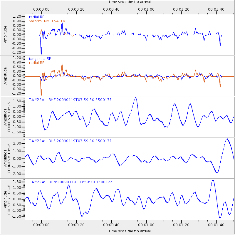
Y22A Socorro, NM, USA - Earthquake Result Viewer
*The percent match for this event was below the threshold and hence no stack was calculated.
| Earthquake location: |
Southeast Of Loyalty Islands |
| Earthquake latitude/longitude: |
-22.5/170.8 |
| Earthquake time(UTC): |
2009/01/19 (019) 03:46:37 GMT |
| Earthquake Depth: |
35 km |
| Earthquake Magnitude: |
6.0 MW, 5.3 MB |
| Earthquake Catalog/Contributor: |
WHDF/NEIC |
|
| Network: |
TA USArray Transportable Network (new EarthScope stations) |
| Station: |
Y22A Socorro, NM, USA |
| Lat/Lon: |
33.94 N/106.97 W |
| Elevation: |
1674 m |
|
| Distance: |
96.2 deg |
| Az: |
55.948 deg |
| Baz: |
247.184 deg |
| Ray Param: |
$rayparam |
*The percent match for this event was below the threshold and hence was not used in the summary stack. |
|
| Radial Match: |
79.8283 % |
| Radial Bump: |
392 |
| Transverse Match: |
45.16009 % |
| Transverse Bump: |
400 |
| SOD ConfigId: |
2658 |
| Insert Time: |
2010-03-06 17:03:11.886 +0000 |
| GWidth: |
2.5 |
| Max Bumps: |
400 |
| Tol: |
0.001 |
|
Signal To Noise
| Channel | StoN | STA | LTA |
| TA:Y22A: :BHZ:20090119T03:59:30.350017Z | 0.5439929 | 1.67508E-7 | 3.0792313E-7 |
| TA:Y22A: :BHN:20090119T03:59:30.350017Z | 1.8752935 | 5.52344E-7 | 2.9453736E-7 |
| TA:Y22A: :BHE:20090119T03:59:30.350017Z | 1.0402365 | 5.008851E-7 | 4.815109E-7 |
| Arrivals |
| Ps | |
| PpPs | |
| PsPs/PpSs | |


