You are here: Home > Network List > TA - USArray Transportable Network (new EarthScope stations) Stations List
> Station Y22A Socorro, NM, USA > Earthquake Result Viewer
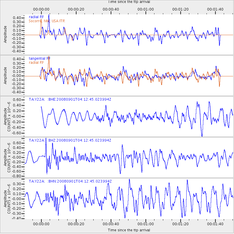
Y22A Socorro, NM, USA - Earthquake Result Viewer
*The percent match for this event was below the threshold and hence no stack was calculated.
| Earthquake location: |
South Of Fiji Islands |
| Earthquake latitude/longitude: |
-25.4/-177.6 |
| Earthquake time(UTC): |
2008/09/01 (245) 04:00:39 GMT |
| Earthquake Depth: |
171 km |
| Earthquake Magnitude: |
5.7 MB, 6.0 MW, 6.0 MW |
| Earthquake Catalog/Contributor: |
WHDF/NEIC |
|
| Network: |
TA USArray Transportable Network (new EarthScope stations) |
| Station: |
Y22A Socorro, NM, USA |
| Lat/Lon: |
33.94 N/106.97 W |
| Elevation: |
1674 m |
|
| Distance: |
89.3 deg |
| Az: |
51.681 deg |
| Baz: |
238.607 deg |
| Ray Param: |
$rayparam |
*The percent match for this event was below the threshold and hence was not used in the summary stack. |
|
| Radial Match: |
56.7123 % |
| Radial Bump: |
400 |
| Transverse Match: |
56.821156 % |
| Transverse Bump: |
400 |
| SOD ConfigId: |
2504 |
| Insert Time: |
2010-03-06 17:03:26.648 +0000 |
| GWidth: |
2.5 |
| Max Bumps: |
400 |
| Tol: |
0.001 |
|
Signal To Noise
| Channel | StoN | STA | LTA |
| TA:Y22A: :BHZ:20080901T04:12:45.023994Z | 2.352337 | 2.7195745E-7 | 1.156116E-7 |
| TA:Y22A: :BHN:20080901T04:12:45.023994Z | 0.6124128 | 6.523465E-8 | 1.06520716E-7 |
| TA:Y22A: :BHE:20080901T04:12:45.023994Z | 0.48679107 | 8.85834E-8 | 1.8197416E-7 |
| Arrivals |
| Ps | |
| PpPs | |
| PsPs/PpSs | |


