You are here: Home > Network List > TA - USArray Transportable Network (new EarthScope stations) Stations List
> Station E20K Nigu River, AK, USA > Earthquake Result Viewer
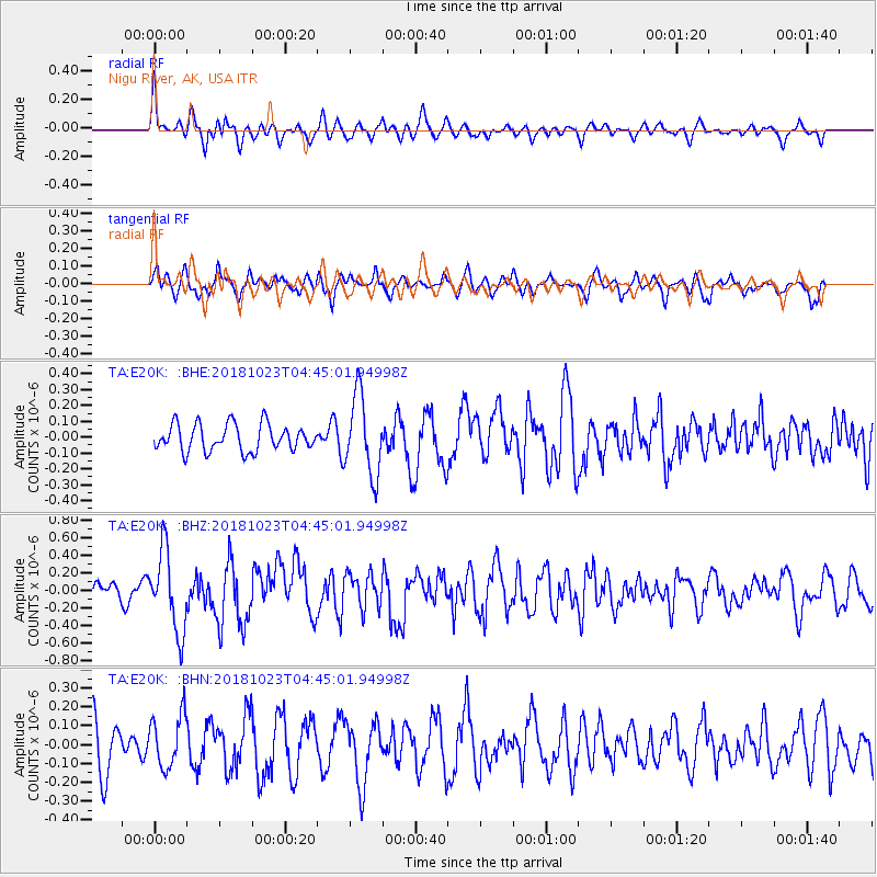
E20K Nigu River, AK, USA - Earthquake Result Viewer
*The percent match for this event was below the threshold and hence no stack was calculated.
| Earthquake location: |
Taiwan Region |
| Earthquake latitude/longitude: |
24.1/122.6 |
| Earthquake time(UTC): |
2018/10/23 (296) 04:34:58 GMT |
| Earthquake Depth: |
34 km |
| Earthquake Magnitude: |
5.7 Mww |
| Earthquake Catalog/Contributor: |
NEIC PDE/us |
|
| Network: |
TA USArray Transportable Network (new EarthScope stations) |
| Station: |
E20K Nigu River, AK, USA |
| Lat/Lon: |
68.26 N/156.19 W |
| Elevation: |
866 m |
|
| Distance: |
64.6 deg |
| Az: |
24.052 deg |
| Baz: |
271.359 deg |
| Ray Param: |
$rayparam |
*The percent match for this event was below the threshold and hence was not used in the summary stack. |
|
| Radial Match: |
61.506855 % |
| Radial Bump: |
389 |
| Transverse Match: |
66.78237 % |
| Transverse Bump: |
400 |
| SOD ConfigId: |
13570011 |
| Insert Time: |
2019-05-01 14:26:44.883 +0000 |
| GWidth: |
2.5 |
| Max Bumps: |
400 |
| Tol: |
0.001 |
|
Signal To Noise
| Channel | StoN | STA | LTA |
| TA:E20K: :BHZ:20181023T04:45:01.94998Z | 3.8532875 | 4.559856E-7 | 1.1833677E-7 |
| TA:E20K: :BHN:20181023T04:45:01.94998Z | 1.1674179 | 1.3911176E-7 | 1.1916193E-7 |
| TA:E20K: :BHE:20181023T04:45:01.94998Z | 2.9607778 | 2.493886E-7 | 8.423076E-8 |
| Arrivals |
| Ps | |
| PpPs | |
| PsPs/PpSs | |


