You are here: Home > Network List > TA - USArray Transportable Network (new EarthScope stations) Stations List
> Station G31M Satah River, YT, CAN > Earthquake Result Viewer
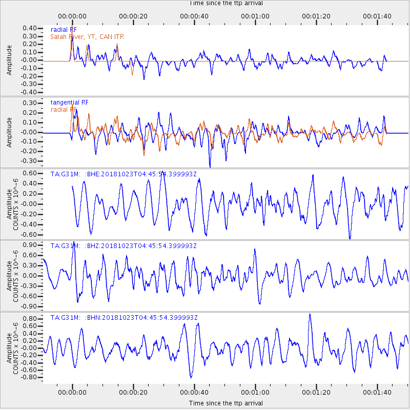
G31M Satah River, YT, CAN - Earthquake Result Viewer
*The percent match for this event was below the threshold and hence no stack was calculated.
| Earthquake location: |
Taiwan Region |
| Earthquake latitude/longitude: |
24.1/122.6 |
| Earthquake time(UTC): |
2018/10/23 (296) 04:34:58 GMT |
| Earthquake Depth: |
34 km |
| Earthquake Magnitude: |
5.7 Mww |
| Earthquake Catalog/Contributor: |
NEIC PDE/us |
|
| Network: |
TA USArray Transportable Network (new EarthScope stations) |
| Station: |
G31M Satah River, YT, CAN |
| Lat/Lon: |
66.92 N/134.27 W |
| Elevation: |
61 m |
|
| Distance: |
73.1 deg |
| Az: |
23.661 deg |
| Baz: |
291.498 deg |
| Ray Param: |
$rayparam |
*The percent match for this event was below the threshold and hence was not used in the summary stack. |
|
| Radial Match: |
41.80056 % |
| Radial Bump: |
377 |
| Transverse Match: |
57.016014 % |
| Transverse Bump: |
379 |
| SOD ConfigId: |
13570011 |
| Insert Time: |
2019-05-01 14:27:11.817 +0000 |
| GWidth: |
2.5 |
| Max Bumps: |
400 |
| Tol: |
0.001 |
|
Signal To Noise
| Channel | StoN | STA | LTA |
| TA:G31M: :BHZ:20181023T04:45:54.399993Z | 1.935218 | 5.039085E-7 | 2.603885E-7 |
| TA:G31M: :BHN:20181023T04:45:54.399993Z | 1.2906046 | 3.3073135E-7 | 2.562608E-7 |
| TA:G31M: :BHE:20181023T04:45:54.399993Z | 1.5050125 | 3.630852E-7 | 2.4125063E-7 |
| Arrivals |
| Ps | |
| PpPs | |
| PsPs/PpSs | |


