You are here: Home > Network List > TA - USArray Transportable Network (new EarthScope stations) Stations List
> Station H16K Elim, AK, USA > Earthquake Result Viewer
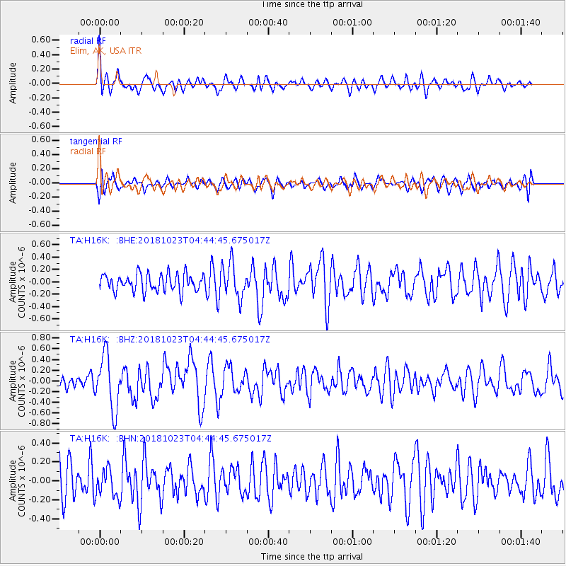
H16K Elim, AK, USA - Earthquake Result Viewer
*The percent match for this event was below the threshold and hence no stack was calculated.
| Earthquake location: |
Taiwan Region |
| Earthquake latitude/longitude: |
24.1/122.6 |
| Earthquake time(UTC): |
2018/10/23 (296) 04:34:58 GMT |
| Earthquake Depth: |
34 km |
| Earthquake Magnitude: |
5.7 Mww |
| Earthquake Catalog/Contributor: |
NEIC PDE/us |
|
| Network: |
TA USArray Transportable Network (new EarthScope stations) |
| Station: |
H16K Elim, AK, USA |
| Lat/Lon: |
64.64 N/162.24 W |
| Elevation: |
216 m |
|
| Distance: |
62.1 deg |
| Az: |
28.09 deg |
| Baz: |
267.625 deg |
| Ray Param: |
$rayparam |
*The percent match for this event was below the threshold and hence was not used in the summary stack. |
|
| Radial Match: |
62.575573 % |
| Radial Bump: |
400 |
| Transverse Match: |
56.76816 % |
| Transverse Bump: |
400 |
| SOD ConfigId: |
13570011 |
| Insert Time: |
2019-05-01 14:27:12.960 +0000 |
| GWidth: |
2.5 |
| Max Bumps: |
400 |
| Tol: |
0.001 |
|
Signal To Noise
| Channel | StoN | STA | LTA |
| TA:H16K: :BHZ:20181023T04:44:45.675017Z | 3.0853965 | 5.177082E-7 | 1.6779309E-7 |
| TA:H16K: :BHN:20181023T04:44:45.675017Z | 0.7241878 | 1.4630676E-7 | 2.0202876E-7 |
| TA:H16K: :BHE:20181023T04:44:45.675017Z | 2.0540557 | 2.842526E-7 | 1.3838603E-7 |
| Arrivals |
| Ps | |
| PpPs | |
| PsPs/PpSs | |


