You are here: Home > Network List > TA - USArray Transportable Network (new EarthScope stations) Stations List
> Station H31M Peel River, Yukon, CAN > Earthquake Result Viewer
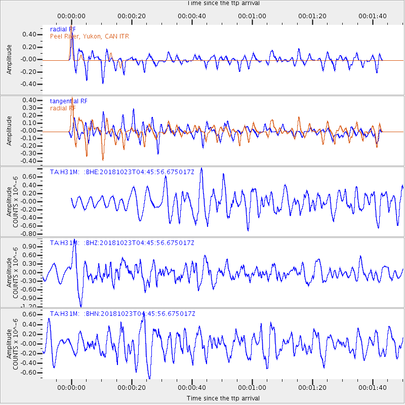
H31M Peel River, Yukon, CAN - Earthquake Result Viewer
*The percent match for this event was below the threshold and hence no stack was calculated.
| Earthquake location: |
Taiwan Region |
| Earthquake latitude/longitude: |
24.1/122.6 |
| Earthquake time(UTC): |
2018/10/23 (296) 04:34:58 GMT |
| Earthquake Depth: |
34 km |
| Earthquake Magnitude: |
5.7 Mww |
| Earthquake Catalog/Contributor: |
NEIC PDE/us |
|
| Network: |
TA USArray Transportable Network (new EarthScope stations) |
| Station: |
H31M Peel River, Yukon, CAN |
| Lat/Lon: |
65.81 N/134.34 W |
| Elevation: |
642 m |
|
| Distance: |
73.5 deg |
| Az: |
24.762 deg |
| Baz: |
291.749 deg |
| Ray Param: |
$rayparam |
*The percent match for this event was below the threshold and hence was not used in the summary stack. |
|
| Radial Match: |
66.85652 % |
| Radial Bump: |
400 |
| Transverse Match: |
61.43199 % |
| Transverse Bump: |
400 |
| SOD ConfigId: |
13570011 |
| Insert Time: |
2019-05-01 14:27:20.840 +0000 |
| GWidth: |
2.5 |
| Max Bumps: |
400 |
| Tol: |
0.001 |
|
Signal To Noise
| Channel | StoN | STA | LTA |
| TA:H31M: :BHZ:20181023T04:45:56.675017Z | 3.3594458 | 6.8436E-7 | 2.0371216E-7 |
| TA:H31M: :BHN:20181023T04:45:56.675017Z | 0.7417801 | 1.4987647E-7 | 2.0204973E-7 |
| TA:H31M: :BHE:20181023T04:45:56.675017Z | 1.9711902 | 3.2327281E-7 | 1.6399879E-7 |
| Arrivals |
| Ps | |
| PpPs | |
| PsPs/PpSs | |


