You are here: Home > Network List > TA - USArray Transportable Network (new EarthScope stations) Stations List
> Station I30M Mount Dempster, Yukon, CAN > Earthquake Result Viewer
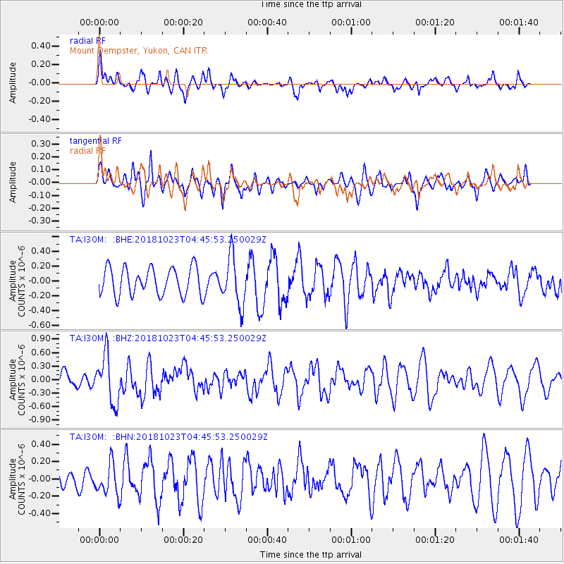
I30M Mount Dempster, Yukon, CAN - Earthquake Result Viewer
*The percent match for this event was below the threshold and hence no stack was calculated.
| Earthquake location: |
Taiwan Region |
| Earthquake latitude/longitude: |
24.1/122.6 |
| Earthquake time(UTC): |
2018/10/23 (296) 04:34:58 GMT |
| Earthquake Depth: |
34 km |
| Earthquake Magnitude: |
5.7 Mww |
| Earthquake Catalog/Contributor: |
NEIC PDE/us |
|
| Network: |
TA USArray Transportable Network (new EarthScope stations) |
| Station: |
I30M Mount Dempster, Yukon, CAN |
| Lat/Lon: |
65.22 N/136.38 W |
| Elevation: |
1399 m |
|
| Distance: |
72.9 deg |
| Az: |
25.65 deg |
| Baz: |
290.157 deg |
| Ray Param: |
$rayparam |
*The percent match for this event was below the threshold and hence was not used in the summary stack. |
|
| Radial Match: |
57.48702 % |
| Radial Bump: |
374 |
| Transverse Match: |
59.17563 % |
| Transverse Bump: |
385 |
| SOD ConfigId: |
13570011 |
| Insert Time: |
2019-05-01 14:27:28.539 +0000 |
| GWidth: |
2.5 |
| Max Bumps: |
400 |
| Tol: |
0.001 |
|
Signal To Noise
| Channel | StoN | STA | LTA |
| TA:I30M: :BHZ:20181023T04:45:53.250029Z | 3.846193 | 5.432321E-7 | 1.412389E-7 |
| TA:I30M: :BHN:20181023T04:45:53.250029Z | 1.4880481 | 1.8364449E-7 | 1.23413E-7 |
| TA:I30M: :BHE:20181023T04:45:53.250029Z | 1.8273249 | 3.4049197E-7 | 1.8633358E-7 |
| Arrivals |
| Ps | |
| PpPs | |
| PsPs/PpSs | |


