You are here: Home > Network List > TA - USArray Transportable Network (new EarthScope stations) Stations List
> Station Z26A Caprock, NM, USA > Earthquake Result Viewer
Z26A Caprock, NM, USA - Earthquake Result Viewer

| Earthquake location: |
Tonga Islands |
| Earthquake latitude/longitude: |
-15.1/-173.5 |
| Earthquake time(UTC): |
2008/08/19 (232) 16:30:13 GMT |
| Earthquake Depth: |
8.0 km |
| Earthquake Magnitude: |
5.6 MB, 5.9 MS, 6.1 MW, 6.0 MW |
| Earthquake Catalog/Contributor: |
WHDF/NEIC |
|
| Network: |
TA USArray Transportable Network (new EarthScope stations) |
| Station: |
Z26A Caprock, NM, USA |
| Lat/Lon: |
33.27 N/103.98 W |
| Elevation: |
1163 m |
|
| Distance: |
81.8 deg |
| Az: |
52.443 deg |
| Baz: |
246.073 deg |
| Ray Param: |
0.0473192 |
| Estimated Moho Depth: |
13.75 km |
| Estimated Crust Vp/Vs: |
1.60 |
| Assumed Crust Vp: |
6.129 km/s |
| Estimated Crust Vs: |
3.831 km/s |
| Estimated Crust Poisson's Ratio: |
0.18 |
|
| Radial Match: |
83.86995 % |
| Radial Bump: |
400 |
| Transverse Match: |
65.62611 % |
| Transverse Bump: |
400 |
| SOD ConfigId: |
2504 |
| Insert Time: |
2010-03-06 17:03:52.743 +0000 |
| GWidth: |
2.5 |
| Max Bumps: |
400 |
| Tol: |
0.001 |
|
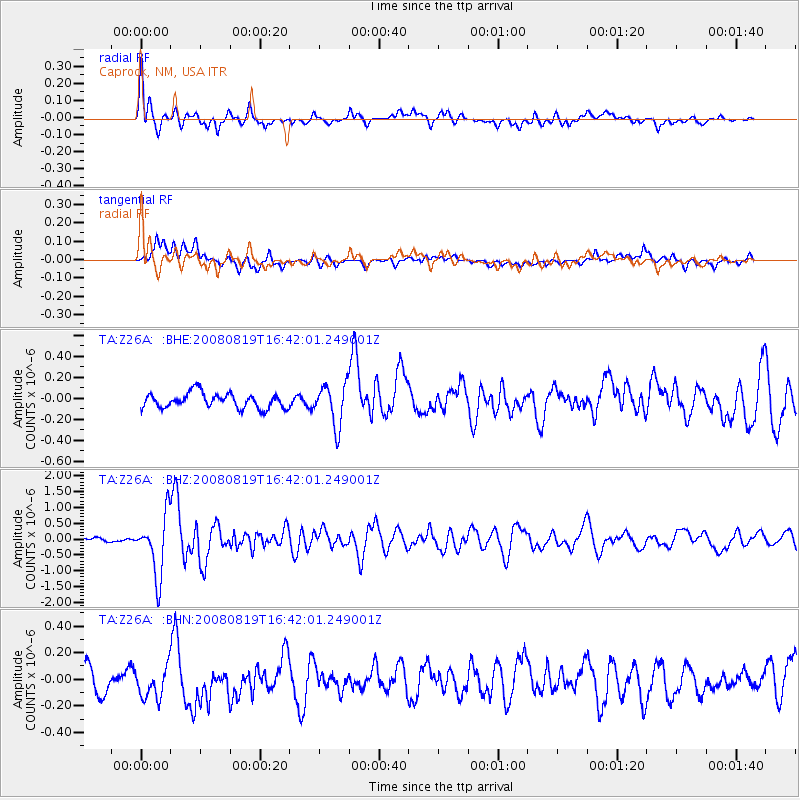
Signal To Noise
| Channel | StoN | STA | LTA |
| TA:Z26A: :BHZ:20080819T16:42:01.249001Z | 10.119753 | 9.512527E-7 | 9.3999596E-8 |
| TA:Z26A: :BHN:20080819T16:42:01.249001Z | 1.1185229 | 1.2197633E-7 | 1.0905125E-7 |
| TA:Z26A: :BHE:20080819T16:42:01.249001Z | 2.800482 | 1.9857247E-7 | 7.090653E-8 |
| Arrivals |
| Ps | 1.4 SECOND |
| PpPs | 5.7 SECOND |
| PsPs/PpSs | 7.1 SECOND |


