Z26A Caprock, NM, USA - Earthquake Result Viewer
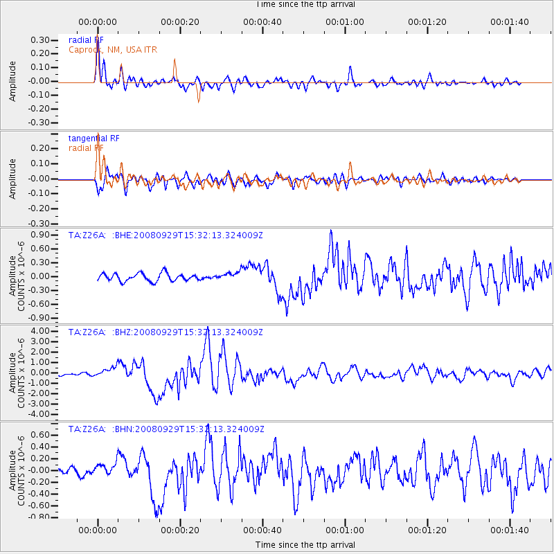
Earthquake location: Kermadec Islands, New Zealand
Earthquake latitude/longitude: -29.8/-177.7
Earthquake time(UTC): 2008/09/29 (273) 15:19:31 GMT
Earthquake Depth: 36 km
Earthquake Magnitude: 6.5 MB, 6.7 MS, 7.0 MW, 7.0 MW
Earthquake Catalog/Contributor: WHDF/NEIC
Network: TA USArray Transportable Network (new EarthScope stations)
Station: Z26A Caprock, NM, USA
Lat/Lon: 33.27 N/103.98 W
Elevation: 1163 m
Distance: 93.7 deg
Az: 53.689 deg
Baz: 236.764 deg
Ray Param: 0.041188788
Estimated Moho Depth: 13.5 km
Estimated Crust Vp/Vs: 1.61
Assumed Crust Vp: 6.129 km/s
Estimated Crust Vs: 3.807 km/s
Estimated Crust Poisson's Ratio: 0.19
Radial Match: 94.29498 %
Radial Bump: 400
Transverse Match: 83.21997 %
Transverse Bump: 400
SOD ConfigId: 2560
Insert Time: 2010-03-06 17:04:05.380 +0000
GWidth: 2.5
Max Bumps: 400
Tol: 0.001

Signal To Noise

ChannelStoNSTALTA
TA:Z26A: :BHZ:20080929T15:32:13.324009Z4.91085.011302E-71.0204655E-7
TA:Z26A: :BHN:20080929T15:32:13.324009Z1.21417271.045914E-78.6142116E-8
TA:Z26A: :BHE:20080929T15:32:13.324009Z1.09045529.1847795E-88.4228866E-8
Arrivals
Ps1.4 SECOND
PpPs5.6 SECOND
PsPs/PpSs7.0 SECOND