You are here: Home > Network List > TA - USArray Transportable Network (new EarthScope stations) Stations List
> Station Z26A Caprock, NM, USA > Earthquake Result Viewer
Z26A Caprock, NM, USA - Earthquake Result Viewer
| Earthquake location: |
South Of Tonga Islands |
| Earthquake latitude/longitude: |
-24.1/-175.2 |
| Earthquake time(UTC): |
2009/11/02 (306) 10:47:13 GMT |
| Earthquake Depth: |
9.0 km |
| Earthquake Magnitude: |
6.1 MB, 6.1 MS, 6.2 MW, 6.1 MW |
| Earthquake Catalog/Contributor: |
WHDF/NEIC |
|
| Network: |
TA USArray Transportable Network (new EarthScope stations) |
| Station: |
Z26A Caprock, NM, USA |
| Lat/Lon: |
33.27 N/103.98 W |
| Elevation: |
1163 m |
|
| Distance: |
88.6 deg |
| Az: |
52.493 deg |
| Baz: |
239.904 deg |
| Ray Param: |
0.04248658 |
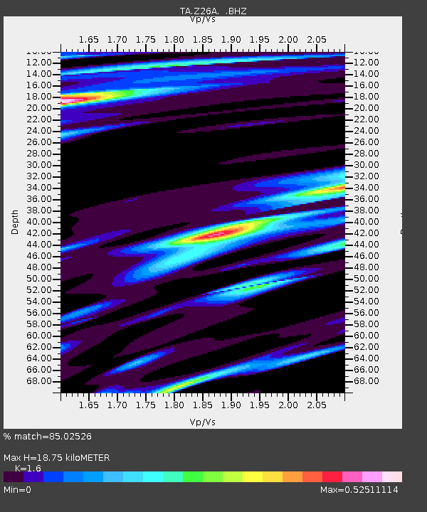
| Estimated Moho Depth: |
18.75 km |
| Estimated Crust Vp/Vs: |
1.60 |
| Assumed Crust Vp: |
6.129 km/s |
| Estimated Crust Vs: |
3.831 km/s |
| Estimated Crust Poisson's Ratio: |
0.18 |
|
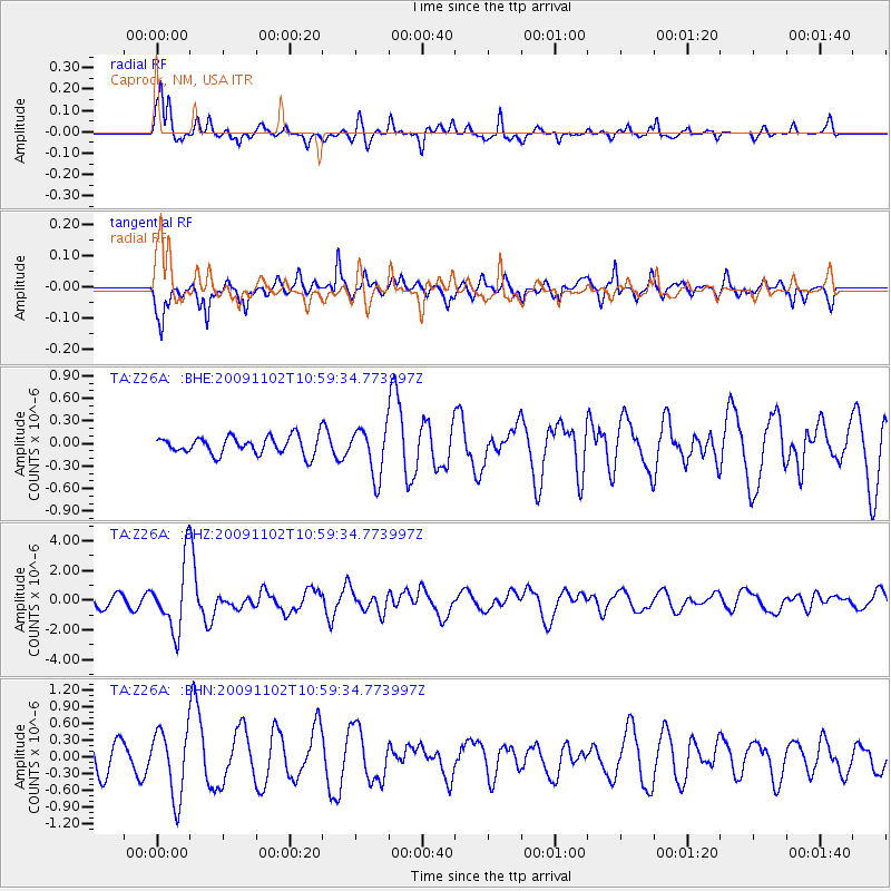
| Radial Match: |
85.02526 % |
| Radial Bump: |
400 |
| Transverse Match: |
75.16222 % |
| Transverse Bump: |
383 |
| SOD ConfigId: |
2622 |
| Insert Time: |
2010-03-06 17:04:35.672 +0000 |
| GWidth: |
2.5 |
| Max Bumps: |
400 |
| Tol: |
0.001 |
|
Signal To Noise
| Channel | StoN | STA | LTA |
| TA:Z26A: :BHZ:20091102T10:59:34.773997Z | 5.9943933 | 2.2513668E-6 | 3.7557876E-7 |
| TA:Z26A: :BHN:20091102T10:59:34.773997Z | 2.330594 | 6.074681E-7 | 2.6064944E-7 |
| TA:Z26A: :BHE:20091102T10:59:34.773997Z | 2.697926 | 3.2096776E-7 | 1.1896832E-7 |
| Arrivals |
| Ps | 1.9 SECOND |
| PpPs | 7.8 SECOND |
| PsPs/PpSs | 9.7 SECOND |


