You are here: Home > Network List > TA - USArray Transportable Network (new EarthScope stations) Stations List
> Station Z26A Caprock, NM, USA > Earthquake Result Viewer
Z26A Caprock, NM, USA - Earthquake Result Viewer
| Earthquake location: |
Northern Mid-Atlantic Ridge |
| Earthquake latitude/longitude: |
23.9/-46.1 |
| Earthquake time(UTC): |
2009/06/06 (157) 20:33:28 GMT |
| Earthquake Depth: |
14 km |
| Earthquake Magnitude: |
6.0 MB, 5.7 MS, 6.0 MW, 6.0 MW |
| Earthquake Catalog/Contributor: |
WHDF/NEIC |
|
| Network: |
TA USArray Transportable Network (new EarthScope stations) |
| Station: |
Z26A Caprock, NM, USA |
| Lat/Lon: |
33.27 N/103.98 W |
| Elevation: |
1163 m |
|
| Distance: |
51.1 deg |
| Az: |
294.322 deg |
| Baz: |
84.753 deg |
| Ray Param: |
0.06759575 |
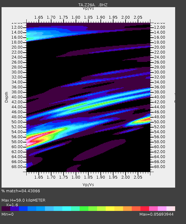
| Estimated Moho Depth: |
59.0 km |
| Estimated Crust Vp/Vs: |
1.60 |
| Assumed Crust Vp: |
6.129 km/s |
| Estimated Crust Vs: |
3.831 km/s |
| Estimated Crust Poisson's Ratio: |
0.18 |
|
| Radial Match: |
84.43866 % |
| Radial Bump: |
400 |
| Transverse Match: |
68.37414 % |
| Transverse Bump: |
400 |
| SOD ConfigId: |
2648 |
| Insert Time: |
2010-03-06 17:04:40.571 +0000 |
| GWidth: |
2.5 |
| Max Bumps: |
400 |
| Tol: |
0.001 |
|

Signal To Noise
| Channel | StoN | STA | LTA |
| TA:Z26A: :BHZ:20090606T20:42:00.125013Z | 5.1825185 | 3.604864E-7 | 6.9558155E-8 |
| TA:Z26A: :BHN:20090606T20:42:00.125013Z | 1.6651728 | 9.6285994E-8 | 5.782342E-8 |
| TA:Z26A: :BHE:20090606T20:42:00.125013Z | 2.577292 | 2.240346E-7 | 8.692635E-8 |
| Arrivals |
| Ps | 6.1 SECOND |
| PpPs | 24 SECOND |
| PsPs/PpSs | 30 SECOND |


