You are here: Home > Network List > TA - USArray Transportable Network (new EarthScope stations) Stations List
> Station F20K Avaraart Lake, AK, USA > Earthquake Result Viewer
F20K Avaraart Lake, AK, USA - Earthquake Result Viewer
*The percent match for this event was below the threshold and hence no stack was calculated.
| Earthquake location: |
Taiwan Region |
| Earthquake latitude/longitude: |
24.0/122.7 |
| Earthquake time(UTC): |
2018/10/23 (296) 16:04:04 GMT |
| Earthquake Depth: |
31 km |
| Earthquake Magnitude: |
5.7 Mww |
| Earthquake Catalog/Contributor: |
NEIC PDE/us |
|
| Network: |
TA USArray Transportable Network (new EarthScope stations) |
| Station: |
F20K Avaraart Lake, AK, USA |
| Lat/Lon: |
67.05 N/155.73 W |
| Elevation: |
136 m |
|
| Distance: |
64.9 deg |
| Az: |
25.367 deg |
| Baz: |
272.221 deg |
| Ray Param: |
$rayparam |
*The percent match for this event was below the threshold and hence was not used in the summary stack. |
|
| Radial Match: |
52.935745 % |
| Radial Bump: |
400 |
| Transverse Match: |
55.18153 % |
| Transverse Bump: |
400 |
| SOD ConfigId: |
13570011 |
| Insert Time: |
2019-05-01 14:35:52.685 +0000 |
| GWidth: |
2.5 |
| Max Bumps: |
400 |
| Tol: |
0.001 |
|
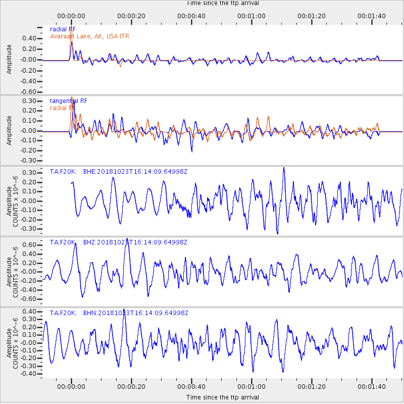
Signal To Noise
| Channel | StoN | STA | LTA |
| TA:F20K: :BHZ:20181023T16:14:09.64998Z | 2.1705022 | 3.6034422E-7 | 1.6601882E-7 |
| TA:F20K: :BHN:20181023T16:14:09.64998Z | 0.9616039 | 1.0243227E-7 | 1.0652231E-7 |
| TA:F20K: :BHE:20181023T16:14:09.64998Z | 1.0229846 | 1.1183897E-7 | 1.0932616E-7 |
| Arrivals |
| Ps | |
| PpPs | |
| PsPs/PpSs | |


