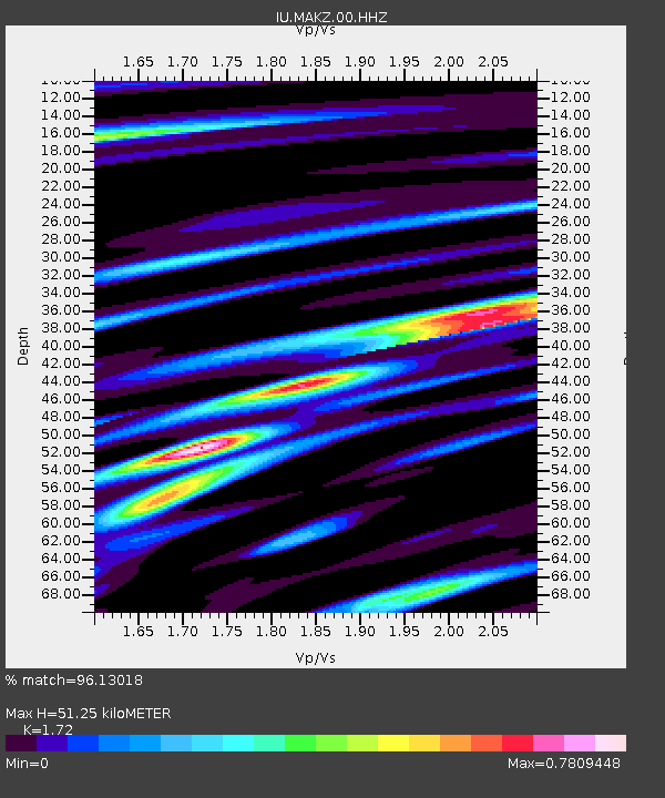
MAKZ Makanchi, Kazakhstan - Earthquake Result Viewer

Earthquake location: Volcano Islands, Japan Region
Earthquake latitude/longitude: 24.9/142.0
Earthquake time(UTC): 2016/08/04 (217) 16:24:33 GMT
Earthquake Depth: 510 km
Earthquake Magnitude: 6.3 MWW, 6.2 MWC, 6.3 MWB, 6.3 MWC
Earthquake Catalog/Contributor: NEIC PDE/NEIC COMCAT
Network: IU Global Seismograph Network (GSN - IRIS/USGS)
Station: MAKZ Makanchi, Kazakhstan
Lat/Lon: 46.81 N/81.98 E
Elevation: 600 m
Distance: 52.0 deg
Az: 310.92 deg
Baz: 93.017 deg
Ray Param: 0.0648659
Estimated Moho Depth: 51.25 km
Estimated Crust Vp/Vs: 1.72
Assumed Crust Vp: 6.571 km/s
Estimated Crust Vs: 3.82 km/s
Estimated Crust Poisson's Ratio: 0.24
Radial Match: 96.13018 %
Radial Bump: 400
Transverse Match: 90.66724 %
Transverse Bump: 400
SOD ConfigId: 1634031
Insert Time: 2016-08-18 16:26:10.061 +0000
GWidth: 2.5
Max Bumps: 400
Tol: 0.001

Signal To Noise

ChannelStoNSTALTA
IU:MAKZ:00:HHZ:20160804T16:32:23.93801Z284.5936.5055083E-62.2858991E-8
IU:MAKZ:00:HH1:20160804T16:32:23.93801Z25.5728174.764866E-71.8632543E-8
IU:MAKZ:00:HH2:20160804T16:32:23.93801Z225.29922.962062E-61.3147237E-8
Arrivals
Ps5.9 SECOND
PpPs20 SECOND
PsPs/PpSs26 SECOND