You are here: Home > Network List > TS - TERRAscope (Southern California Seismic Network) Stations List
> Station BAR Barrett Dam, California, USA > Earthquake Result Viewer
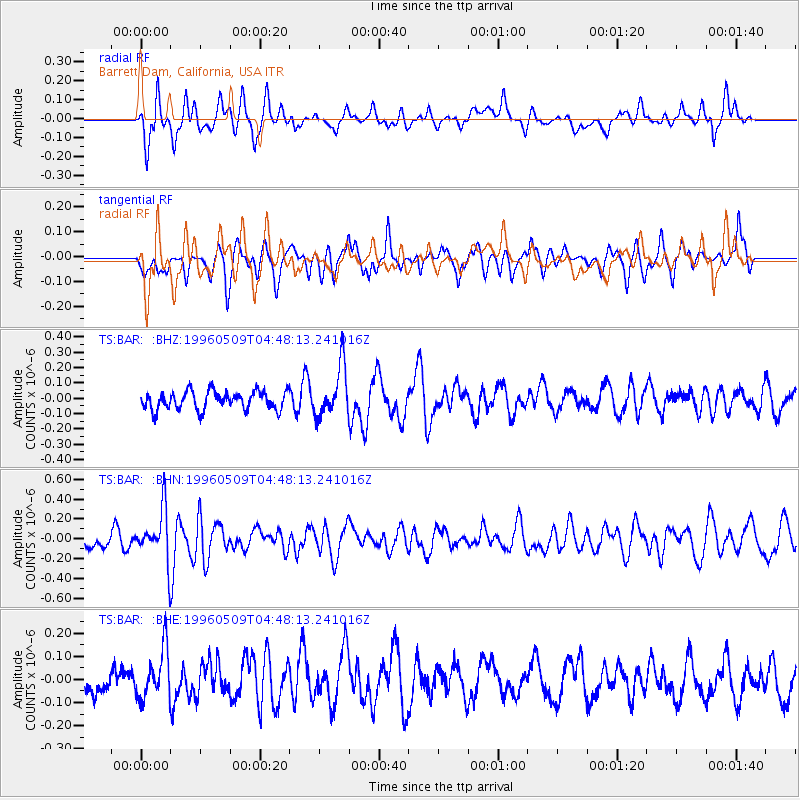
BAR Barrett Dam, California, USA - Earthquake Result Viewer
*The percent match for this event was below the threshold and hence no stack was calculated.
| Earthquake location: |
South Of Kermadec Islands |
| Earthquake latitude/longitude: |
-32.6/-179.4 |
| Earthquake time(UTC): |
1996/05/09 (130) 04:36:03 GMT |
| Earthquake Depth: |
77 km |
| Earthquake Magnitude: |
5.8 UNKNOWN, 5.0 MS, 5.4 MB |
| Earthquake Catalog/Contributor: |
WHDF/NEIC |
|
| Network: |
TS TERRAscope (Southern California Seismic Network) |
| Station: |
BAR Barrett Dam, California, USA |
| Lat/Lon: |
32.68 N/116.67 W |
| Elevation: |
548 m |
|
| Distance: |
87.8 deg |
| Az: |
48.593 deg |
| Baz: |
228.643 deg |
| Ray Param: |
$rayparam |
*The percent match for this event was below the threshold and hence was not used in the summary stack. |
|
| Radial Match: |
65.63522 % |
| Radial Bump: |
400 |
| Transverse Match: |
51.325985 % |
| Transverse Bump: |
354 |
| SOD ConfigId: |
4480 |
| Insert Time: |
2010-02-26 13:59:23.864 +0000 |
| GWidth: |
2.5 |
| Max Bumps: |
400 |
| Tol: |
0.001 |
|
Signal To Noise
| Channel | StoN | STA | LTA |
| TS:BAR: :BHN:19960509T04:48:13.241016Z | 2.2841444 | 2.56535E-7 | 1.123112E-7 |
| TS:BAR: :BHE:19960509T04:48:13.241016Z | 1.3696891 | 1.09625816E-7 | 8.0037005E-8 |
| TS:BAR: :BHZ:19960509T04:48:13.241016Z | 2.7024627 | 1.6218397E-7 | 6.00134E-8 |
| Arrivals |
| Ps | |
| PpPs | |
| PsPs/PpSs | |


