You are here: Home > Network List > TA - USArray Transportable Network (new EarthScope stations) Stations List
> Station Z26A Caprock, NM, USA > Earthquake Result Viewer
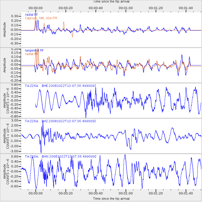
Z26A Caprock, NM, USA - Earthquake Result Viewer
*The percent match for this event was below the threshold and hence no stack was calculated.
| Earthquake location: |
Tonga Islands |
| Earthquake latitude/longitude: |
-18.4/-175.4 |
| Earthquake time(UTC): |
2008/10/22 (296) 12:55:57 GMT |
| Earthquake Depth: |
233 km |
| Earthquake Magnitude: |
5.9 MB, 6.4 MW, 6.3 MW |
| Earthquake Catalog/Contributor: |
WHDF/NEIC |
|
| Network: |
TA USArray Transportable Network (new EarthScope stations) |
| Station: |
Z26A Caprock, NM, USA |
| Lat/Lon: |
33.27 N/103.98 W |
| Elevation: |
1163 m |
|
| Distance: |
85.3 deg |
| Az: |
52.806 deg |
| Baz: |
244.525 deg |
| Ray Param: |
$rayparam |
*The percent match for this event was below the threshold and hence was not used in the summary stack. |
|
| Radial Match: |
72.47232 % |
| Radial Bump: |
400 |
| Transverse Match: |
49.449783 % |
| Transverse Bump: |
321 |
| SOD ConfigId: |
2560 |
| Insert Time: |
2010-03-06 17:05:46.911 +0000 |
| GWidth: |
2.5 |
| Max Bumps: |
400 |
| Tol: |
0.001 |
|
Signal To Noise
| Channel | StoN | STA | LTA |
| TA:Z26A: :BHZ:20081022T13:07:36.499009Z | 5.1893415 | 1.135439E-6 | 2.1880213E-7 |
| TA:Z26A: :BHN:20081022T13:07:36.499009Z | 1.7420584 | 3.6456626E-7 | 2.0927327E-7 |
| TA:Z26A: :BHE:20081022T13:07:36.499009Z | 1.2470961 | 3.59074E-7 | 2.879281E-7 |
| Arrivals |
| Ps | |
| PpPs | |
| PsPs/PpSs | |


