You are here: Home > Network List > TA - USArray Transportable Network (new EarthScope stations) Stations List
> Station Z26A Caprock, NM, USA > Earthquake Result Viewer
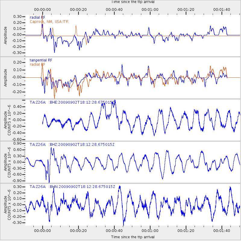
Z26A Caprock, NM, USA - Earthquake Result Viewer
*The percent match for this event was below the threshold and hence no stack was calculated.
| Earthquake location: |
Kermadec Islands, New Zealand |
| Earthquake latitude/longitude: |
-29.4/-179.0 |
| Earthquake time(UTC): |
2009/09/02 (245) 18:00:11 GMT |
| Earthquake Depth: |
275 km |
| Earthquake Magnitude: |
5.8 MB, 6.2 MW, 6.1 MW |
| Earthquake Catalog/Contributor: |
WHDF/NEIC |
|
| Network: |
TA USArray Transportable Network (new EarthScope stations) |
| Station: |
Z26A Caprock, NM, USA |
| Lat/Lon: |
33.27 N/103.98 W |
| Elevation: |
1163 m |
|
| Distance: |
94.4 deg |
| Az: |
54.245 deg |
| Baz: |
237.742 deg |
| Ray Param: |
$rayparam |
*The percent match for this event was below the threshold and hence was not used in the summary stack. |
|
| Radial Match: |
78.919266 % |
| Radial Bump: |
400 |
| Transverse Match: |
61.30496 % |
| Transverse Bump: |
400 |
| SOD ConfigId: |
2622 |
| Insert Time: |
2010-03-06 17:05:58.277 +0000 |
| GWidth: |
2.5 |
| Max Bumps: |
400 |
| Tol: |
0.001 |
|
Signal To Noise
| Channel | StoN | STA | LTA |
| TA:Z26A: :BHZ:20090902T18:12:28.675015Z | 4.4444017 | 4.1833135E-7 | 9.4125454E-8 |
| TA:Z26A: :BHN:20090902T18:12:28.675015Z | 1.5395929 | 1.0879276E-7 | 7.066333E-8 |
| TA:Z26A: :BHE:20090902T18:12:28.675015Z | 3.2840104 | 3.556803E-7 | 1.0830669E-7 |
| Arrivals |
| Ps | |
| PpPs | |
| PsPs/PpSs | |


