You are here: Home > Network List > TA - USArray Transportable Network (new EarthScope stations) Stations List
> Station G21K Allakaket, AK, USA > Earthquake Result Viewer
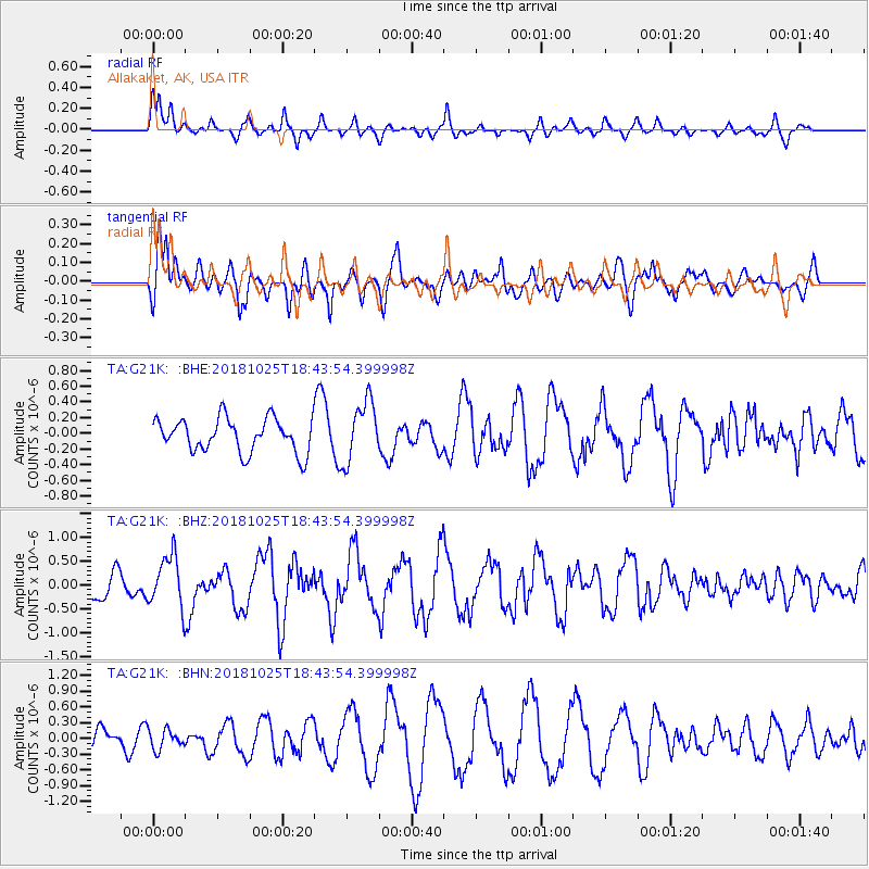
G21K Allakaket, AK, USA - Earthquake Result Viewer
*The percent match for this event was below the threshold and hence no stack was calculated.
| Earthquake location: |
Near East Coast Of Honshu, Japan |
| Earthquake latitude/longitude: |
38.3/141.8 |
| Earthquake time(UTC): |
2018/10/25 (298) 18:36:09 GMT |
| Earthquake Depth: |
40 km |
| Earthquake Magnitude: |
5.7 Mww |
| Earthquake Catalog/Contributor: |
NEIC PDE/us |
|
| Network: |
TA USArray Transportable Network (new EarthScope stations) |
| Station: |
G21K Allakaket, AK, USA |
| Lat/Lon: |
66.52 N/153.51 W |
| Elevation: |
446 m |
|
| Distance: |
45.5 deg |
| Az: |
30.506 deg |
| Baz: |
265.142 deg |
| Ray Param: |
$rayparam |
*The percent match for this event was below the threshold and hence was not used in the summary stack. |
|
| Radial Match: |
68.78051 % |
| Radial Bump: |
400 |
| Transverse Match: |
63.93547 % |
| Transverse Bump: |
361 |
| SOD ConfigId: |
13570011 |
| Insert Time: |
2019-05-01 14:45:51.192 +0000 |
| GWidth: |
2.5 |
| Max Bumps: |
400 |
| Tol: |
0.001 |
|
Signal To Noise
| Channel | StoN | STA | LTA |
| TA:G21K: :BHZ:20181025T18:43:54.399998Z | 2.4917376 | 5.393309E-7 | 2.1644773E-7 |
| TA:G21K: :BHN:20181025T18:43:54.399998Z | 0.6759963 | 1.8800954E-7 | 2.7812214E-7 |
| TA:G21K: :BHE:20181025T18:43:54.399998Z | 1.8008245 | 3.8645817E-7 | 2.1460069E-7 |
| Arrivals |
| Ps | |
| PpPs | |
| PsPs/PpSs | |


