You are here: Home > Network List > TA - USArray Transportable Network (new EarthScope stations) Stations List
> Station Z26A Caprock, NM, USA > Earthquake Result Viewer
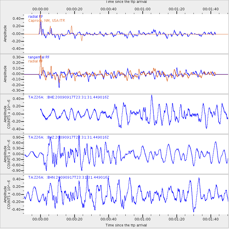
Z26A Caprock, NM, USA - Earthquake Result Viewer
*The percent match for this event was below the threshold and hence no stack was calculated.
| Earthquake location: |
Easter Island Region |
| Earthquake latitude/longitude: |
-29.1/-112.3 |
| Earthquake time(UTC): |
2009/09/17 (260) 23:21:38 GMT |
| Earthquake Depth: |
10 km |
| Earthquake Magnitude: |
5.7 MB, 6.0 MS, 6.2 MW, 6.2 MW |
| Earthquake Catalog/Contributor: |
WHDF/NEIC |
|
| Network: |
TA USArray Transportable Network (new EarthScope stations) |
| Station: |
Z26A Caprock, NM, USA |
| Lat/Lon: |
33.27 N/103.98 W |
| Elevation: |
1163 m |
|
| Distance: |
62.6 deg |
| Az: |
7.819 deg |
| Baz: |
188.167 deg |
| Ray Param: |
$rayparam |
*The percent match for this event was below the threshold and hence was not used in the summary stack. |
|
| Radial Match: |
67.32643 % |
| Radial Bump: |
400 |
| Transverse Match: |
65.63632 % |
| Transverse Bump: |
400 |
| SOD ConfigId: |
2622 |
| Insert Time: |
2010-03-06 17:06:02.589 +0000 |
| GWidth: |
2.5 |
| Max Bumps: |
400 |
| Tol: |
0.001 |
|
Signal To Noise
| Channel | StoN | STA | LTA |
| TA:Z26A: :BHZ:20090917T23:31:31.449016Z | 3.2308052 | 3.537007E-7 | 1.09477575E-7 |
| TA:Z26A: :BHN:20090917T23:31:31.449016Z | 1.4549598 | 1.2273456E-7 | 8.435598E-8 |
| TA:Z26A: :BHE:20090917T23:31:31.449016Z | 1.1118599 | 9.578879E-8 | 8.615186E-8 |
| Arrivals |
| Ps | |
| PpPs | |
| PsPs/PpSs | |


