You are here: Home > Network List > TS - TERRAscope (Southern California Seismic Network) Stations List
> Station BAR Barrett Dam, California, USA > Earthquake Result Viewer
BAR Barrett Dam, California, USA - Earthquake Result Viewer
*The percent match for this event was below the threshold and hence no stack was calculated.
| Earthquake location: |
Near East Coast Of Kamchatka |
| Earthquake latitude/longitude: |
55.2/161.9 |
| Earthquake time(UTC): |
1997/02/09 (040) 18:57:37 GMT |
| Earthquake Depth: |
33 km |
| Earthquake Magnitude: |
5.9 MB, 5.3 MS, 5.8 UNKNOWN, 5.7 MW |
| Earthquake Catalog/Contributor: |
WHDF/NEIC |
|
| Network: |
TS TERRAscope (Southern California Seismic Network) |
| Station: |
BAR Barrett Dam, California, USA |
| Lat/Lon: |
32.68 N/116.67 W |
| Elevation: |
548 m |
|
| Distance: |
59.1 deg |
| Az: |
76.234 deg |
| Baz: |
318.724 deg |
| Ray Param: |
$rayparam |
*The percent match for this event was below the threshold and hence was not used in the summary stack. |
|
| Radial Match: |
53.842766 % |
| Radial Bump: |
400 |
| Transverse Match: |
60.32757 % |
| Transverse Bump: |
400 |
| SOD ConfigId: |
4480 |
| Insert Time: |
2010-02-26 13:59:25.400 +0000 |
| GWidth: |
2.5 |
| Max Bumps: |
400 |
| Tol: |
0.001 |
|
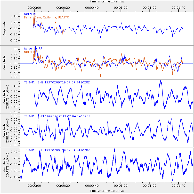
Signal To Noise
| Channel | StoN | STA | LTA |
| TS:BAR: :BHN:19970209T19:07:04.541028Z | 1.4234549 | 3.063008E-7 | 2.1518123E-7 |
| TS:BAR: :BHE:19970209T19:07:04.541028Z | 0.9359771 | 2.0454188E-7 | 2.1853299E-7 |
| TS:BAR: :BHZ:19970209T19:07:04.541028Z | 1.1161278 | 2.0797073E-7 | 1.8633236E-7 |
| Arrivals |
| Ps | |
| PpPs | |
| PsPs/PpSs | |


