You are here: Home > Network List > TA - USArray Transportable Network (new EarthScope stations) Stations List
> Station Z26A Caprock, NM, USA > Earthquake Result Viewer
Z26A Caprock, NM, USA - Earthquake Result Viewer
*The percent match for this event was below the threshold and hence no stack was calculated.
| Earthquake location: |
Central Peru |
| Earthquake latitude/longitude: |
-14.5/-70.4 |
| Earthquake time(UTC): |
2009/03/15 (074) 08:19:05 GMT |
| Earthquake Depth: |
190 km |
| Earthquake Magnitude: |
5.7 MW, 5.1 MB, 5.6 MW |
| Earthquake Catalog/Contributor: |
WHDF/NEIC |
|
| Network: |
TA USArray Transportable Network (new EarthScope stations) |
| Station: |
Z26A Caprock, NM, USA |
| Lat/Lon: |
33.27 N/103.98 W |
| Elevation: |
1163 m |
|
| Distance: |
57.3 deg |
| Az: |
326.548 deg |
| Baz: |
140.4 deg |
| Ray Param: |
$rayparam |
*The percent match for this event was below the threshold and hence was not used in the summary stack. |
|
| Radial Match: |
45.509583 % |
| Radial Bump: |
353 |
| Transverse Match: |
71.52755 % |
| Transverse Bump: |
400 |
| SOD ConfigId: |
2658 |
| Insert Time: |
2010-03-06 17:06:30.166 +0000 |
| GWidth: |
2.5 |
| Max Bumps: |
400 |
| Tol: |
0.001 |
|
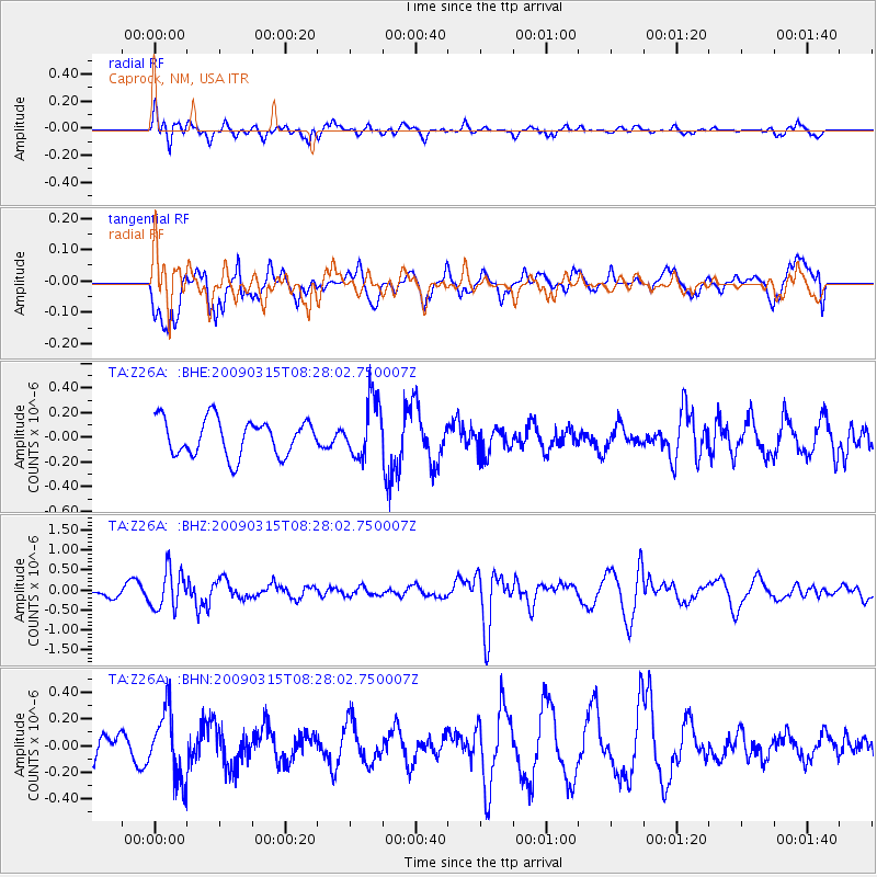
Signal To Noise
| Channel | StoN | STA | LTA |
| TA:Z26A: :BHZ:20090315T08:28:02.750007Z | 3.255935 | 4.851969E-7 | 1.4901923E-7 |
| TA:Z26A: :BHN:20090315T08:28:02.750007Z | 1.8838044 | 2.543713E-7 | 1.3503063E-7 |
| TA:Z26A: :BHE:20090315T08:28:02.750007Z | 1.5951653 | 2.3320801E-7 | 1.4619678E-7 |
| Arrivals |
| Ps | |
| PpPs | |
| PsPs/PpSs | |


