You are here: Home > Network List > TA - USArray Transportable Network (new EarthScope stations) Stations List
> Station Z26A Caprock, NM, USA > Earthquake Result Viewer
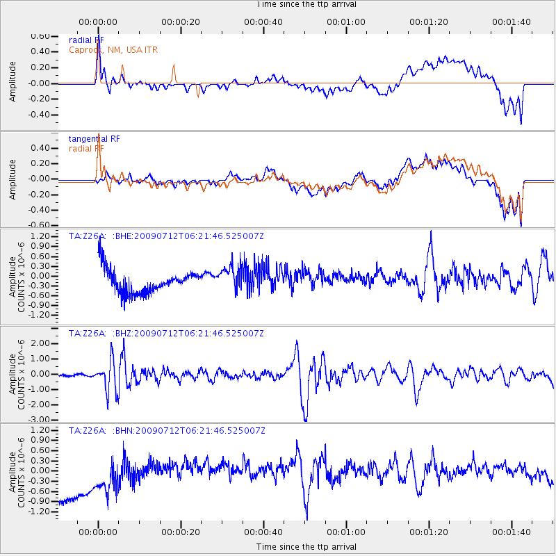
Z26A Caprock, NM, USA - Earthquake Result Viewer
*The percent match for this event was below the threshold and hence no stack was calculated.
| Earthquake location: |
Southern Peru |
| Earthquake latitude/longitude: |
-15.0/-70.4 |
| Earthquake time(UTC): |
2009/07/12 (193) 06:12:47 GMT |
| Earthquake Depth: |
199 km |
| Earthquake Magnitude: |
5.7 MB, 6.1 MW, 6.1 MW |
| Earthquake Catalog/Contributor: |
WHDF/NEIC |
|
| Network: |
TA USArray Transportable Network (new EarthScope stations) |
| Station: |
Z26A Caprock, NM, USA |
| Lat/Lon: |
33.27 N/103.98 W |
| Elevation: |
1163 m |
|
| Distance: |
57.7 deg |
| Az: |
326.815 deg |
| Baz: |
140.858 deg |
| Ray Param: |
$rayparam |
*The percent match for this event was below the threshold and hence was not used in the summary stack. |
|
| Radial Match: |
32.38075 % |
| Radial Bump: |
400 |
| Transverse Match: |
32.362144 % |
| Transverse Bump: |
400 |
| SOD ConfigId: |
2648 |
| Insert Time: |
2010-03-06 17:06:36.945 +0000 |
| GWidth: |
2.5 |
| Max Bumps: |
400 |
| Tol: |
0.001 |
|
Signal To Noise
| Channel | StoN | STA | LTA |
| TA:Z26A: :BHZ:20090712T06:21:46.525007Z | 8.829049 | 1.0261738E-6 | 1.1622698E-7 |
| TA:Z26A: :BHN:20090712T06:21:46.525007Z | 0.60081005 | 1.0650724E-6 | 1.7727274E-6 |
| TA:Z26A: :BHE:20090712T06:21:46.525007Z | 1.1003833 | 3.9151556E-7 | 3.5579927E-7 |
| Arrivals |
| Ps | |
| PpPs | |
| PsPs/PpSs | |


