You are here: Home > Network List > TA - USArray Transportable Network (new EarthScope stations) Stations List
> Station Z26A Caprock, NM, USA > Earthquake Result Viewer
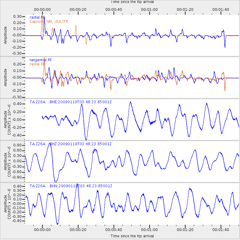
Z26A Caprock, NM, USA - Earthquake Result Viewer
*The percent match for this event was below the threshold and hence no stack was calculated.
| Earthquake location: |
Southeast Of Loyalty Islands |
| Earthquake latitude/longitude: |
-22.6/170.9 |
| Earthquake time(UTC): |
2009/01/19 (019) 03:35:18 GMT |
| Earthquake Depth: |
12 km |
| Earthquake Magnitude: |
5.7 MB, 6.4 MS, 6.5 MW, 6.5 MW |
| Earthquake Catalog/Contributor: |
WHDF/NEIC |
|
| Network: |
TA USArray Transportable Network (new EarthScope stations) |
| Station: |
Z26A Caprock, NM, USA |
| Lat/Lon: |
33.27 N/103.98 W |
| Elevation: |
1163 m |
|
| Distance: |
98.2 deg |
| Az: |
57.494 deg |
| Baz: |
248.48 deg |
| Ray Param: |
$rayparam |
*The percent match for this event was below the threshold and hence was not used in the summary stack. |
|
| Radial Match: |
53.15661 % |
| Radial Bump: |
399 |
| Transverse Match: |
58.8549 % |
| Transverse Bump: |
379 |
| SOD ConfigId: |
2658 |
| Insert Time: |
2010-03-06 17:06:38.442 +0000 |
| GWidth: |
2.5 |
| Max Bumps: |
400 |
| Tol: |
0.001 |
|
Signal To Noise
| Channel | StoN | STA | LTA |
| TA:Z26A: :BHZ:20090119T03:48:23.85001Z | 2.5004365 | 6.3537976E-7 | 2.541075E-7 |
| TA:Z26A: :BHN:20090119T03:48:23.85001Z | 1.3591019 | 1.9404115E-7 | 1.427716E-7 |
| TA:Z26A: :BHE:20090119T03:48:23.85001Z | 0.9688887 | 1.4798886E-7 | 1.5274082E-7 |
| Arrivals |
| Ps | |
| PpPs | |
| PsPs/PpSs | |


