You are here: Home > Network List > IU - Global Seismograph Network (GSN - IRIS/USGS) Stations List
> Station PMSA Palmer Station, Antarctica > Earthquake Result Viewer
PMSA Palmer Station, Antarctica - Earthquake Result Viewer
| Earthquake location: |
Jujuy Province, Argentina |
| Earthquake latitude/longitude: |
-23.0/-66.6 |
| Earthquake time(UTC): |
2009/11/14 (318) 19:44:29 GMT |
| Earthquake Depth: |
220 km |
| Earthquake Magnitude: |
5.8 MB, 6.2 MW, 6.1 MW |
| Earthquake Catalog/Contributor: |
WHDF/NEIC |
|
| Network: |
IU Global Seismograph Network (GSN - IRIS/USGS) |
| Station: |
PMSA Palmer Station, Antarctica |
| Lat/Lon: |
64.77 S/64.05 W |
| Elevation: |
40 m |
|
| Distance: |
41.8 deg |
| Az: |
178.335 deg |
| Baz: |
356.417 deg |
| Ray Param: |
0.07268338 |
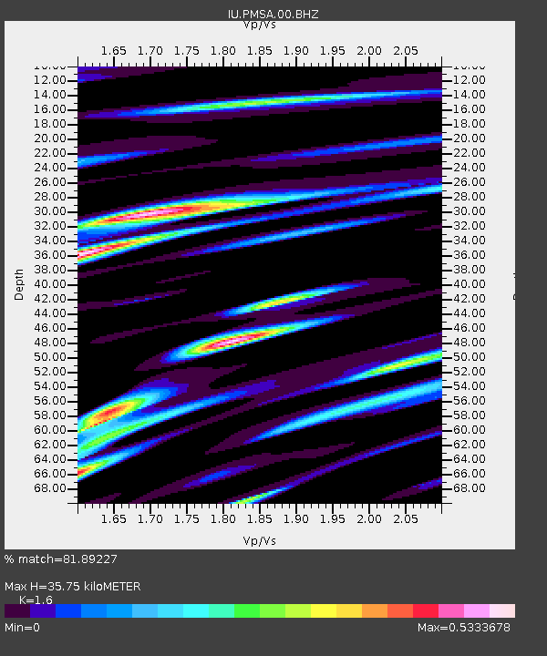
| Estimated Moho Depth: |
35.75 km |
| Estimated Crust Vp/Vs: |
1.60 |
| Assumed Crust Vp: |
6.183 km/s |
| Estimated Crust Vs: |
3.864 km/s |
| Estimated Crust Poisson's Ratio: |
0.18 |
|
| Radial Match: |
81.89227 % |
| Radial Bump: |
400 |
| Transverse Match: |
62.33484 % |
| Transverse Bump: |
400 |
| SOD ConfigId: |
1 |
| Insert Time: |
2010-02-19 01:11:45.015 +0000 |
| GWidth: |
2.5 |
| Max Bumps: |
400 |
| Tol: |
0.001 |
|

Signal To Noise
| Channel | StoN | STA | LTA |
| IU:PMSA:00:BHZ:20091114T19:51:27.536995Z | 9.40024 | 1.3333479E-6 | 1.4184191E-7 |
| IU:PMSA:00:BHN:20091114T19:51:27.536995Z | 5.2863984 | 7.596588E-7 | 1.4370063E-7 |
| IU:PMSA:00:BHE:20091114T19:51:27.536995Z | 1.2526369 | 2.339108E-7 | 1.8673472E-7 |
| Arrivals |
| Ps | 3.7 SECOND |
| PpPs | 14 SECOND |
| PsPs/PpSs | 18 SECOND |


