You are here: Home > Network List > TA - USArray Transportable Network (new EarthScope stations) Stations List
> Station Z26A Caprock, NM, USA > Earthquake Result Viewer
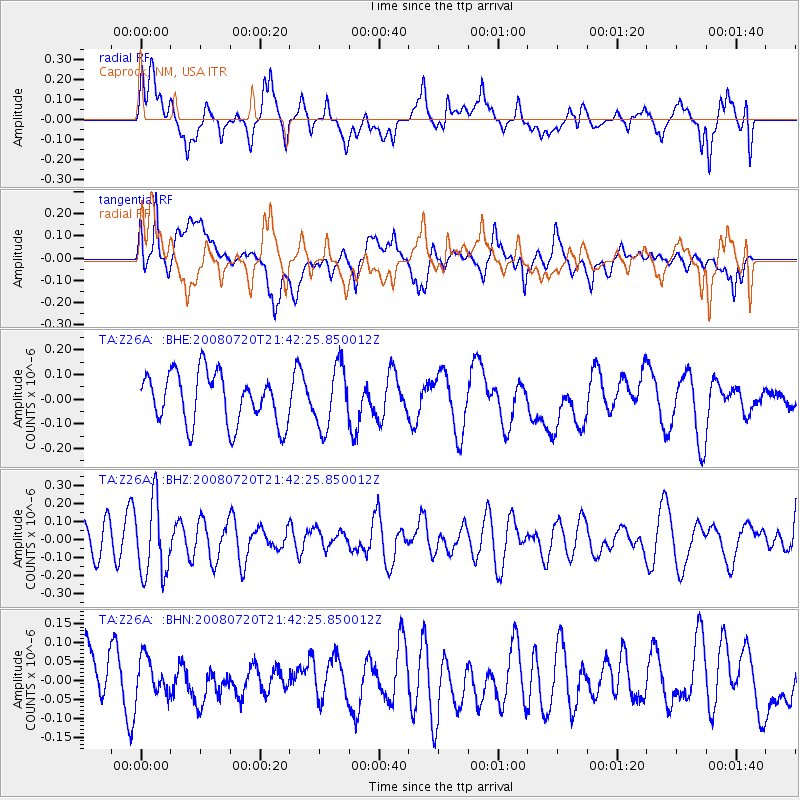
Z26A Caprock, NM, USA - Earthquake Result Viewer
*The percent match for this event was below the threshold and hence no stack was calculated.
| Earthquake location: |
Bonin Islands, Japan Region |
| Earthquake latitude/longitude: |
27.8/139.6 |
| Earthquake time(UTC): |
2008/07/20 (202) 21:30:29 GMT |
| Earthquake Depth: |
481 km |
| Earthquake Magnitude: |
5.8 MW, 5.1 MB, 5.8 MW |
| Earthquake Catalog/Contributor: |
WHDF/NEIC |
|
| Network: |
TA USArray Transportable Network (new EarthScope stations) |
| Station: |
Z26A Caprock, NM, USA |
| Lat/Lon: |
33.27 N/103.98 W |
| Elevation: |
1163 m |
|
| Distance: |
94.4 deg |
| Az: |
48.816 deg |
| Baz: |
307.25 deg |
| Ray Param: |
$rayparam |
*The percent match for this event was below the threshold and hence was not used in the summary stack. |
|
| Radial Match: |
51.92 % |
| Radial Bump: |
400 |
| Transverse Match: |
52.354885 % |
| Transverse Bump: |
400 |
| SOD ConfigId: |
2504 |
| Insert Time: |
2010-03-06 17:06:57.993 +0000 |
| GWidth: |
2.5 |
| Max Bumps: |
400 |
| Tol: |
0.001 |
|
Signal To Noise
| Channel | StoN | STA | LTA |
| TA:Z26A: :BHZ:20080720T21:42:25.850012Z | 1.8103459 | 2.0839377E-7 | 1.15112684E-7 |
| TA:Z26A: :BHN:20080720T21:42:25.850012Z | 0.72519433 | 5.0014187E-8 | 6.89666E-8 |
| TA:Z26A: :BHE:20080720T21:42:25.850012Z | 1.2231586 | 1.2548941E-7 | 1.02594555E-7 |
| Arrivals |
| Ps | |
| PpPs | |
| PsPs/PpSs | |


