You are here: Home > Network List > N4 - Central and EAstern US Network Stations List
> Station Z35B Perchaven, Sanger, TX, USA > Earthquake Result Viewer
Z35B Perchaven, Sanger, TX, USA - Earthquake Result Viewer
| Earthquake location: |
Ionian Sea |
| Earthquake latitude/longitude: |
37.5/20.6 |
| Earthquake time(UTC): |
2018/10/25 (298) 22:54:52 GMT |
| Earthquake Depth: |
14 km |
| Earthquake Magnitude: |
6.8 Mww |
| Earthquake Catalog/Contributor: |
NEIC PDE/us |
|
| Network: |
N4 Central and EAstern US Network |
| Station: |
Z35B Perchaven, Sanger, TX, USA |
| Lat/Lon: |
33.33 N/97.25 W |
| Elevation: |
234 m |
|
| Distance: |
88.8 deg |
| Az: |
312.216 deg |
| Baz: |
44.703 deg |
| Ray Param: |
0.04231151 |
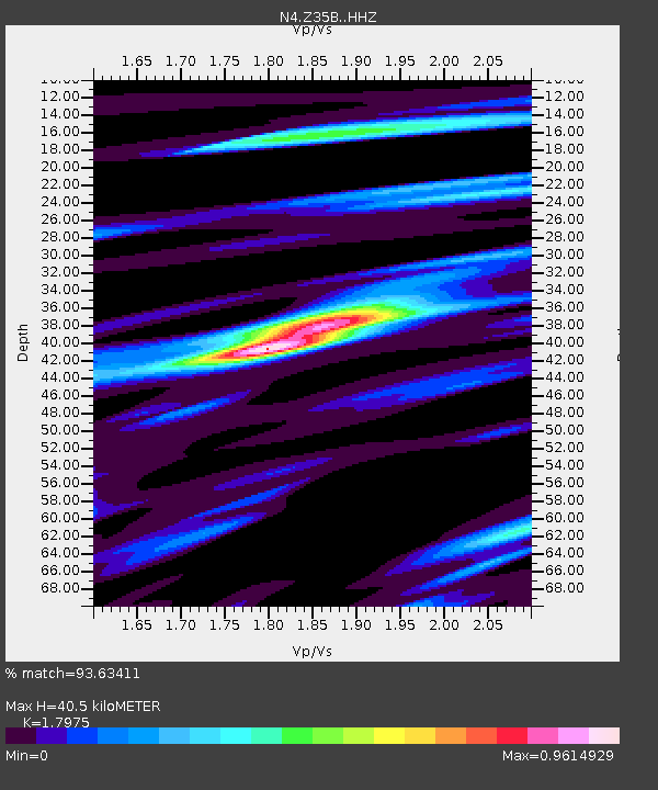
| Estimated Moho Depth: |
40.5 km |
| Estimated Crust Vp/Vs: |
1.80 |
| Assumed Crust Vp: |
6.38 km/s |
| Estimated Crust Vs: |
3.55 km/s |
| Estimated Crust Poisson's Ratio: |
0.28 |
|
| Radial Match: |
93.63411 % |
| Radial Bump: |
343 |
| Transverse Match: |
89.9284 % |
| Transverse Bump: |
400 |
| SOD ConfigId: |
13570011 |
| Insert Time: |
2019-05-01 14:54:23.870 +0000 |
| GWidth: |
2.5 |
| Max Bumps: |
400 |
| Tol: |
0.001 |
|

Signal To Noise
| Channel | StoN | STA | LTA |
| N4:Z35B: :HHZ:20181025T23:07:14.340Z | 4.6319623 | 6.378404E-7 | 1.3770415E-7 |
| N4:Z35B: :HHN:20181025T23:07:14.340Z | 2.2715845 | 3.3531813E-7 | 1.476142E-7 |
| N4:Z35B: :HHE:20181025T23:07:14.340Z | 1.790869 | 2.2966262E-7 | 1.2824088E-7 |
| Arrivals |
| Ps | 5.2 SECOND |
| PpPs | 17 SECOND |
| PsPs/PpSs | 23 SECOND |


