You are here: Home > Network List > TA - USArray Transportable Network (new EarthScope stations) Stations List
> Station Z26A Caprock, NM, USA > Earthquake Result Viewer
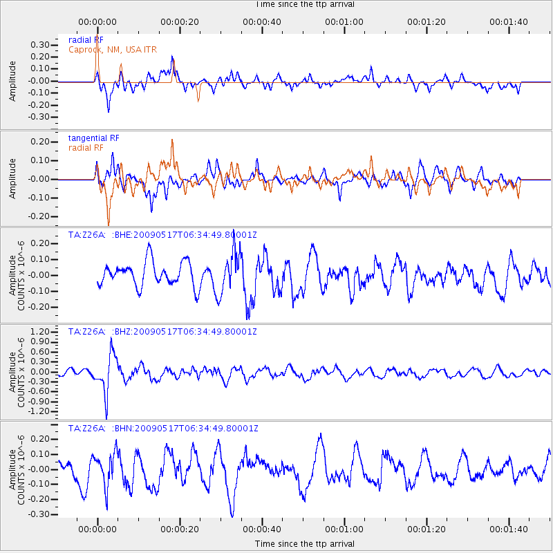
Z26A Caprock, NM, USA - Earthquake Result Viewer
*The percent match for this event was below the threshold and hence no stack was calculated.
| Earthquake location: |
Tonga Islands |
| Earthquake latitude/longitude: |
-16.8/-173.5 |
| Earthquake time(UTC): |
2009/05/17 (137) 06:23:03 GMT |
| Earthquake Depth: |
67 km |
| Earthquake Magnitude: |
5.5 MB, 5.6 MW, 5.6 MW |
| Earthquake Catalog/Contributor: |
WHDF/NEIC |
|
| Network: |
TA USArray Transportable Network (new EarthScope stations) |
| Station: |
Z26A Caprock, NM, USA |
| Lat/Lon: |
33.27 N/103.98 W |
| Elevation: |
1163 m |
|
| Distance: |
82.9 deg |
| Az: |
52.265 deg |
| Baz: |
244.702 deg |
| Ray Param: |
$rayparam |
*The percent match for this event was below the threshold and hence was not used in the summary stack. |
|
| Radial Match: |
72.05842 % |
| Radial Bump: |
400 |
| Transverse Match: |
58.297035 % |
| Transverse Bump: |
400 |
| SOD ConfigId: |
2760 |
| Insert Time: |
2010-03-06 17:07:16.487 +0000 |
| GWidth: |
2.5 |
| Max Bumps: |
400 |
| Tol: |
0.001 |
|
Signal To Noise
| Channel | StoN | STA | LTA |
| TA:Z26A: :BHZ:20090517T06:34:49.80001Z | 6.0421605 | 5.843757E-7 | 9.671634E-8 |
| TA:Z26A: :BHN:20090517T06:34:49.80001Z | 1.9571795 | 1.08783446E-7 | 5.558174E-8 |
| TA:Z26A: :BHE:20090517T06:34:49.80001Z | 1.746096 | 1.3093585E-7 | 7.498777E-8 |
| Arrivals |
| Ps | |
| PpPs | |
| PsPs/PpSs | |


